
Why Is Canada’s Population so Concentrated?

Canada’s federal elections are this Monday, so I thought it was a good occasion to answer some fascinating questions about the country, like why is 50% of Canada’s population concentrated here?

And 70% here?

Why does the average Canadian live in the US?

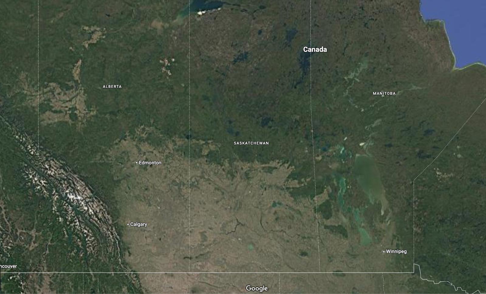
If there’s a housing crisis in Canada, why don’t they build houses in this area:

What goes on here?

Why doesn’t Canada own this?

Why does most of Canada look like an alien planet?

Why is there a huge diagonal string of large lakes in the middle of Canada?

And more, like why is Alberta so different from the rest of Canada? To fully answer these questions, it will take more than one article, so subscribe to get them if you haven’t yet.
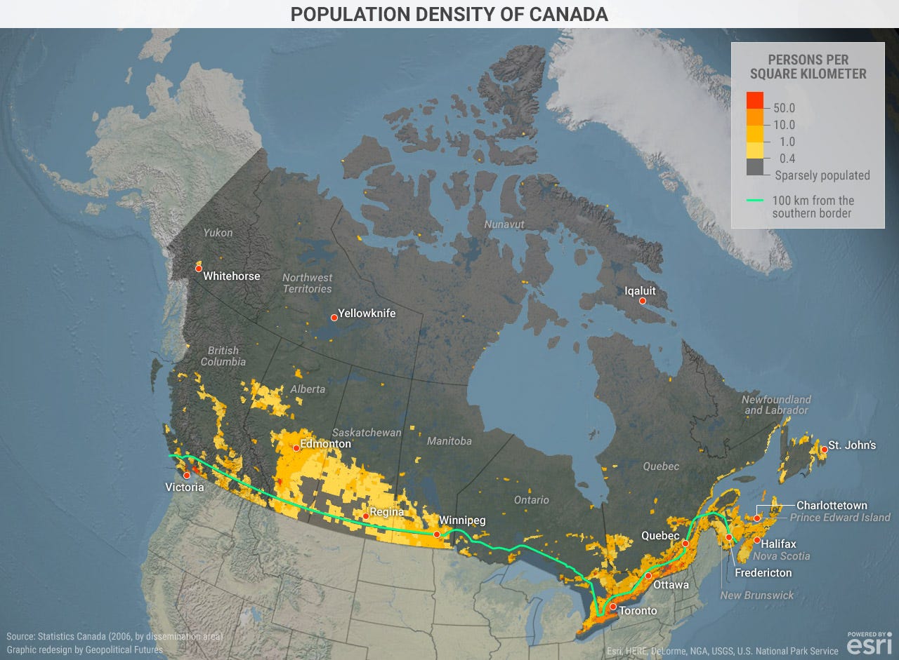
The most salient fact about Canada is how concentrated its population is:
But you’ll also notice something else: There are several centers of population, and they’re pretty disconnected from each other!

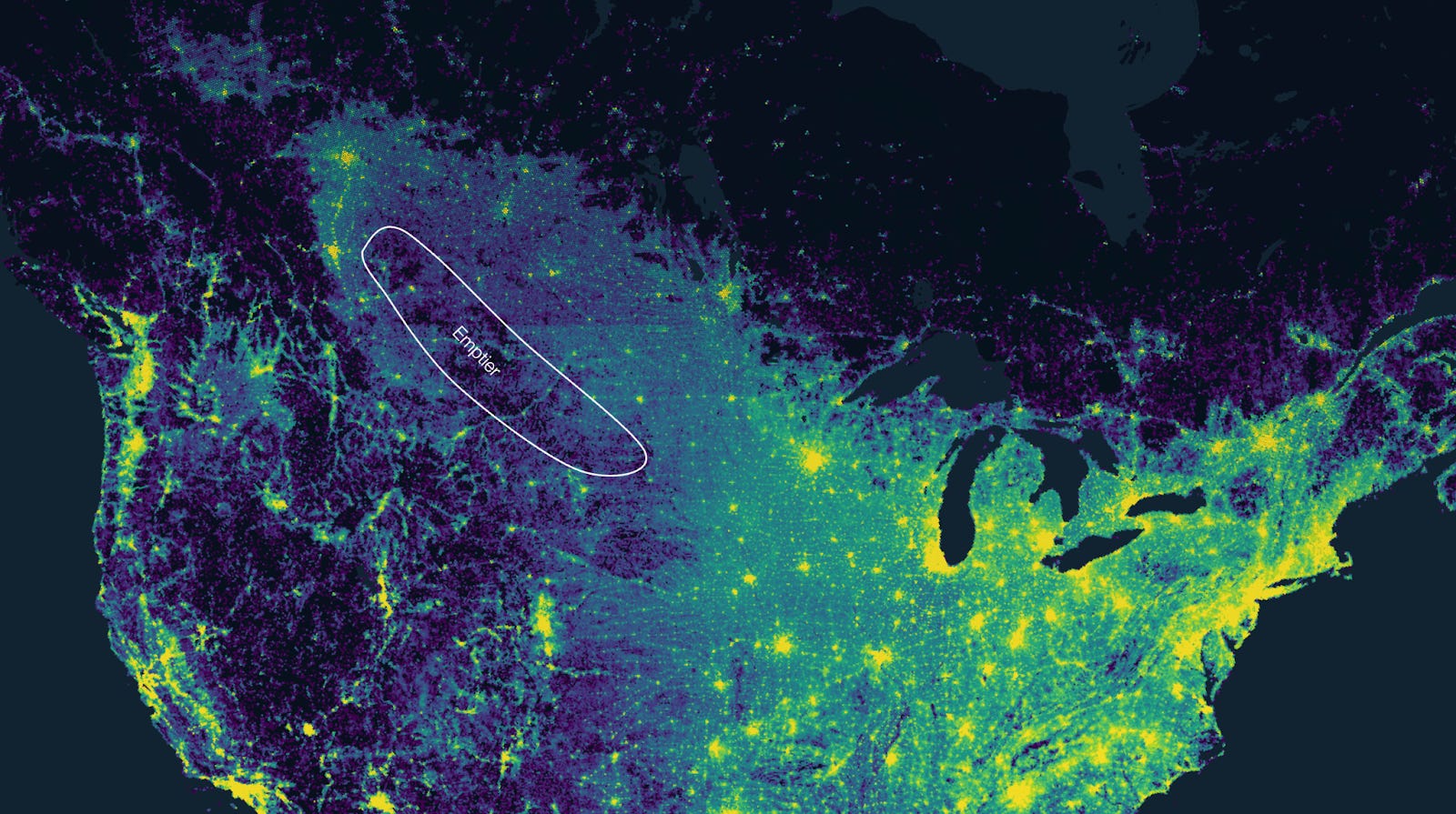
What’s going on doesn’t become clear until you see a map of nightlights of all North America:

Where’s the border between the US and Canada?
The same is true for roads:

Even better, look at this map of population density:

Can you tell where the border is? You probably can’t. Let me draw it for you:

If you need to draw a line on a population map to tell where there’s a border, that border does not separate much. Two facts are surprising about Canada’s population areas:
They are indistinguishable from the US’s
They are disconnected from each other!
Over 80% of Canadians live within 100 miles of the US border. In other words: Canada’s population areas are extensions of US population areas!
Of course, this is the biggest reason:
But it’s not the only one:
Why are these precise regions populated, and not others?
Why no more population in between these regions?
Why is so much of Canada empty?
If the two countries are so connected, why are they not a single country?
The answer is here:

Because it causes this:

First, let’s zoom in on the East.
1. Canada’s East
This is why most Canadians live in the east of the country.

Canada, like all of America, was colonized from the east—where Europeans came from. Ships would arrive from the Atlantic, and the farther inland they could go, the better it was for trade. And there are two rivers that travel very far inland in North America: the St Lawrence, and the Mississippi. This is why the map of North America looked like this in 1702:
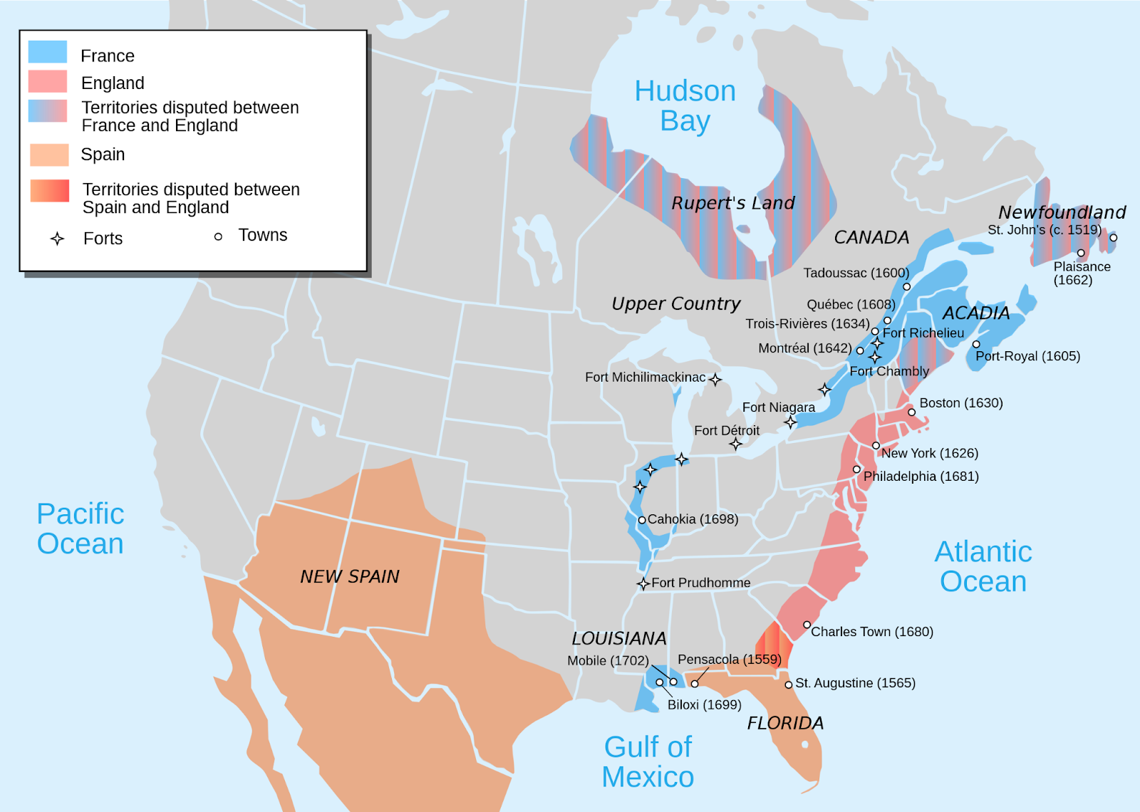
While Spain focused on its Central and South America holdings, and England on the Atlantic Seaboard, France was trying to control the valleys of both the Mississippi and the St Lawrence, hoping to connect them. It succeeded later that century:

That’s why the French-speaking part of Canada is where it is:

As I describe in How New York Beat Montréal and Québec, Québec City is where it is because it's a perfect point to defend the St Lawrence entrance: It has a big hill that overlooks the estuary, which is narrow enough at this point to be easy to control. Alas, the hills are too high for a good port, so that city could never become the biggest one in the region.

That honor would go to the head of navigation: The farthest point a seafaring ship could navigate upstream. That point became Montréal.
For centuries after that, the British and then Canadians worked to make the rest of the St Lawrence navigable, to reach the Great Lakes, which they achieved in the mid 1800s and continued improving through the 20th century. That’s when Toronto really started to thrive.
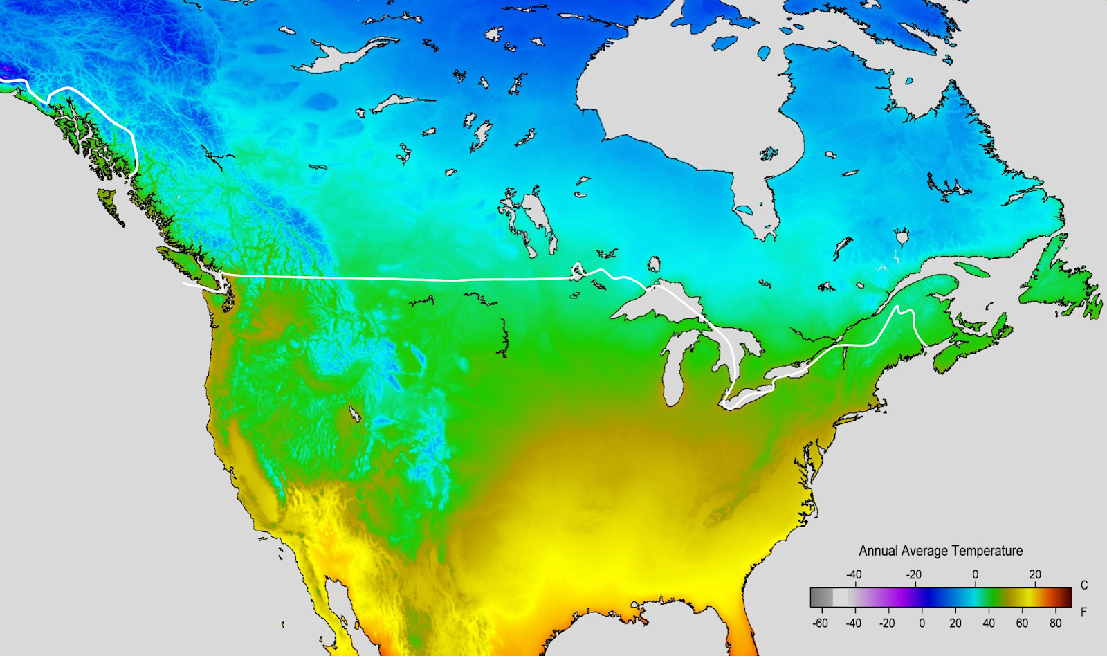
But if you look closely, something weird is happening here. Look at the population density again. Why is there so much population south of the St Lawrence, but it stops very quickly north of it?

Of course, a part of it is the cold, but not only that:
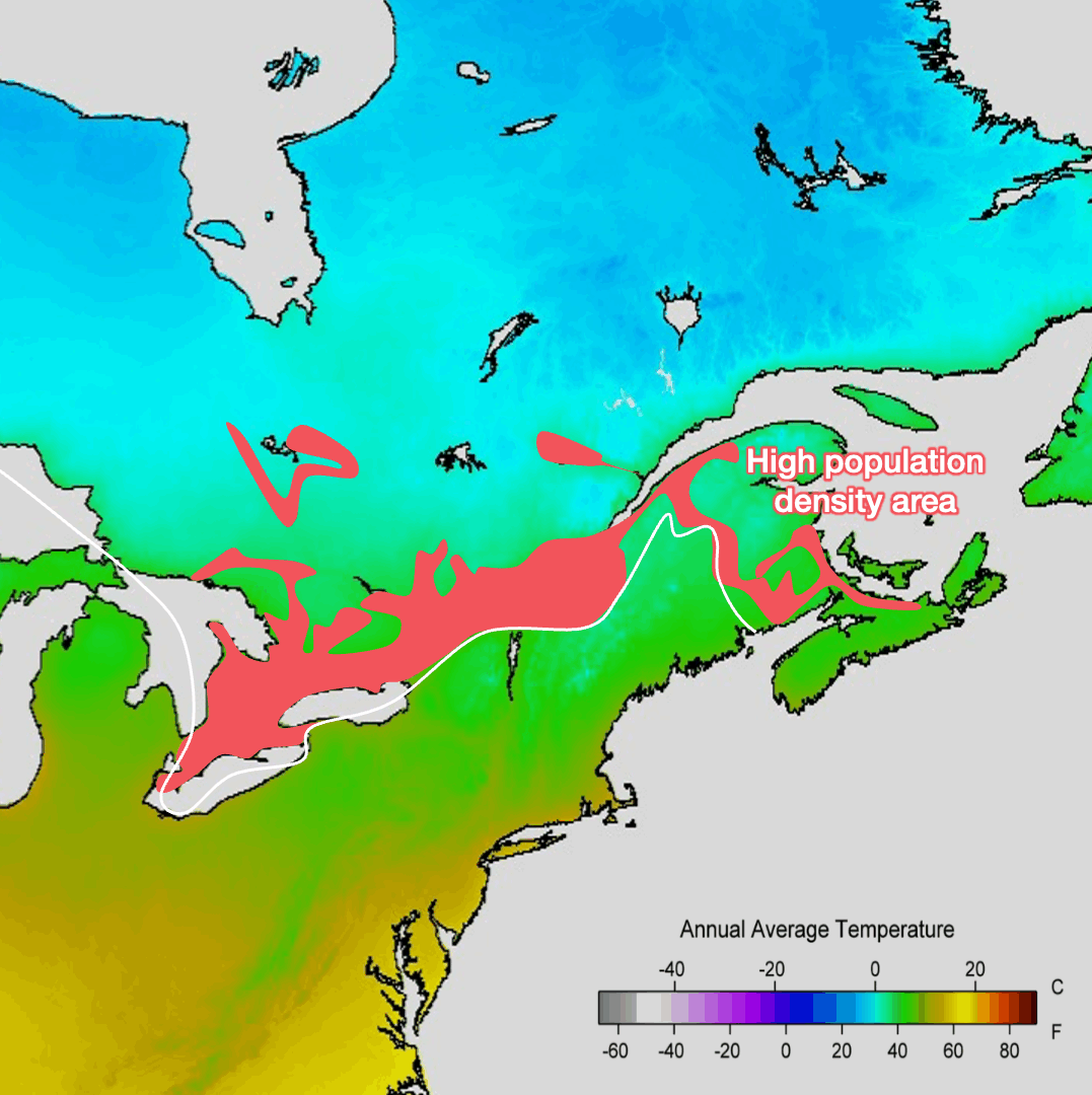
The most densely populated areas, in red, are indeed warmer on average, but there are other areas that are similarly warm and don’t have population. So?
2. Canada’s Center
A huge reason is the Canadian Shield.
The Canadian Shield

What does the Canadian Shield look like?

It is barren land, with rock sticking out of the little soil left from eons of glaciers stripping it bare.
But the ice sheet covered much of Canada:

Why is only this area so barren? Because of the underlying soil:

The red and orange are the shield. It’s very hard granite rock, over a billion years old, which ice could not easily weather. Ice stripped all the pre-existing soil, leaving bare rock or a very thin layer of soil.
Meanwhile, notice the green area just west of it? That is some of the most fertile land on Earth:

Why is it so crazily fertile?
Because there was a sea here!

Here’s what North America and its Western Interior Seaway looked like:

The Palliser Triangle
The remnants of sea life and sediments accumulated there for millions of years. Since then, millions of years of grasses growing and dying there made it even more fertile. The sea, the soil, farmland, and population all overlap:

That’s the Palliser Triangle, where you find cities like Calgary, Edmonton, and Winnipeg.
The west and north edges are more populated than the center and south. Why?

This area is warmer on average than the surrounding region. However:

As we explained in this article, this dry area is caused by the Rockies west of it, which catch all the rain, leaving very little for the prairies.
Notice that the dry conditions of the prairie continue south—that’s why the triangle actually continues further south into the US, and has a lower density of population there:
So in summary for the Palliser Triangle: It’s in the middle of pretty hostile land, with very tall mountains to the west, the infertile soil of the Canadian Shield to the east, too much cold in the north, and not enough water in the south. But the west and northeast edges of the Palliser Triangle have a set of uniquely welcoming features:
Fertile soil thanks to the ancient sea that was here
Warmer climate than its surroundings
More rain than its surroundings, and watered by the mountains to the west.
All this explains why this area is the 2nd big population center of Canada.
3. The Coast
The last big population center is on the west coast. But there, the population is even more concentrated:

The population is extremely concentrated in Vancouver. A zoom in on the population density map illustrates this:

About 3M people concentrate in Vancouver and its surroundings. Why not farther afield?

Mountains! They’re on the sea here, while the interior valley is further north and inland than in the US. We can see it in a picture of Vancouver:

We’re now ready to answer our questions!
Takeaways
Why is 50% of Canada’s population concentrated in the lower southeast?
Because:
It’s the warmest
It has plenty of water
The soil is fertile
It has access to international trade through the Great Lakes and the St Lawrence River
This is where Europeans initially arrived
It couldn’t grow much northward in the past because of the cold and the Canadian Shield, which is completely sterile.
Why are there only two other big centers of population?
One is the west and northeast edges of the Palliser Triangle. It has a unique combination of:
Fertile soil, west of the Canadian Shield because it used to be a shallow sea
Warm enough in summer to grow crops
With enough rain and rivers from the Rockies to irrigate the fields
The other one is Vancouver and its surroundings, which happens to be the sole valley that crosses the Coastal Mountains.
Why is the north so completely empty?
It’s not just the cold. It’s also quite dry in some areas, and a big chunk of it is covered by the Canadian Shield.
Now that we know this, we can ask ourselves many more questions:
What are the geopolitics of Canada? What are its priorities?
Why is Alberta such an outlier in Canada?
What’s going on in the north of the country?
What should we do about Trump’s taunting that Canada should become the US’s 51st state?
Why didn’t Canada join the US when it declared its independence from Britain?
What are the craziest moments that determined Canada’s history?
Will Québec ever split?
How many immigrants can Canada accept?
Why does it have such a big housing crisis despite all this available land?
Why does Alaska extend south into Canada’s coast?
Why is there a line of lakes in the middle of Canada?
These are some of the things we’re going to explore in the upcoming articles, some of which will be premium!
Thanks for this -- thought I knew it all, having lived in or spent a lot of time in all those regions, but it was great to see you line up the demographics with the geography and history. Re the 51st state business: Of course, we Canadians were amused, then appalled -- then enraged. It was fascinating to track in one's own heart the rise of nationalist fervour, which, since Canada is 'the mouse living next to the elephant', as Trudeau père said, is something we usually keep in check. But more coolly... if a unification were to happen peacefully, it would be absurd to create a state that was bigger than all the other states combined -- 13 states would make more sense, to match the number of provinces and territories. Quebec and New Brunswick would need to have French as an official language. The Electoral College would be upended -- I doubt a Republican would ever be President again. The Senate would get 26 more Senators -- 21 of them would be more 'liberal' than most Democrats. Universal publicly funded health care would be demanded.... and immediately save the USA economy money and deliver better services. Indigenous voices would be much stronger. And the Army might discover peacekeeping! Of course, if annexation were violent and unwilling -- well, the US occupations of Vietnam, Iraq and Afghanistan might be a good guide to what would happen. Not sure if either model is attractive to USA-ers?
Great overview and use of maps to understand why Canadian population is located across Canada. I look forward to reading the next string of articles addressing the many interesting questions raised. Of course, one of them is particularly thorny, about the 51st state... as a naturalized Canadian myself, I've been amazed at the reaction to Trump's annexation discourse, which was first taken as a joke, then as a threat, and as a betrayal. In terms of scenarios, I agree with the comment below from Barry Stevens. Trump's approach has united Canadians (with the Liberals most likely retaining power, something unthinkable a few months ago), I do wonder about the strategy behind, like much of Trump's foreign policy.
One thing I'd like to point out in the article is this sentence, which I believe contradicts the explanations provided: "In other words: Canada’s population areas are extensions of US population areas!" Because of the current political sensitivity, I think this sentence can be misinterpreted, and I believe it is historically inaccurate, as the article demonstrates, i.e. cities in Canada were built along the St Lawrence's exploration from the Atlantic, it didn't come from the US up-north, as an extension of US cities...