25 Fascinating Facts about Mexico
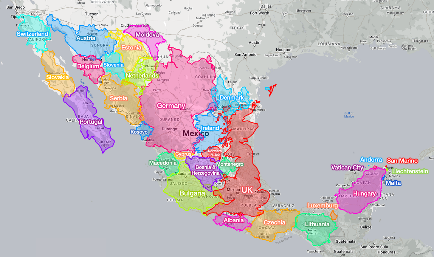
Mexico is huge! It’s hard to comprehend. You can fit 30 European countries in Mexico and still have room to spare.
Here it is, compared to Greenland:
And compared to the US, Canada, Greenland, and Europe:
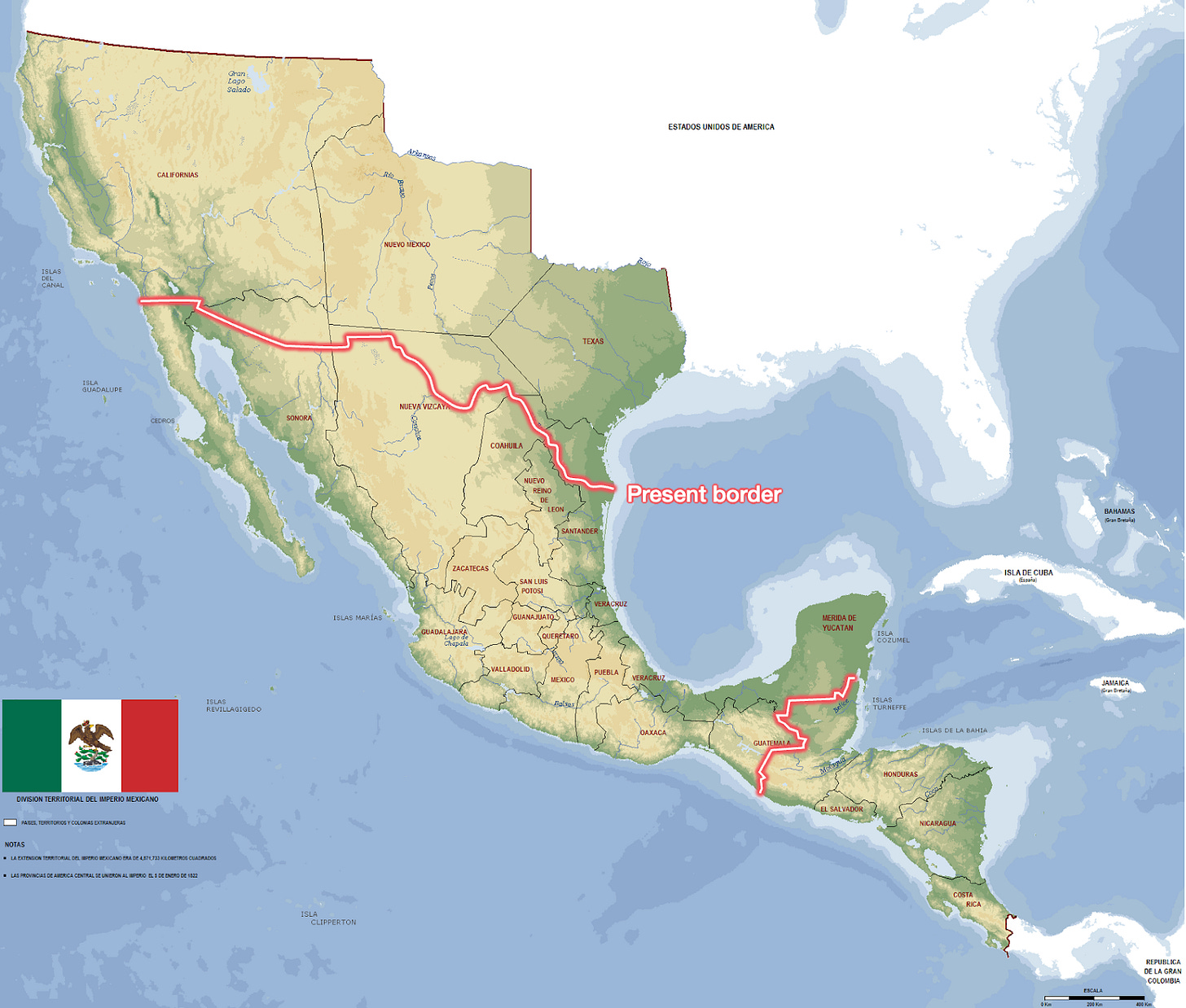
As big as Mexico is now, it used to be much bigger.
In the 1846-48 war with the US, the US took 55% of Mexico’s land!
Mexico has by far the most Spanish speakers in the world.
It’s been invaded six times through Veracruz! Three of these times, the invaders managed to reach Mexico City, making Veracruz Mexico’s Achilles Heel.
It does not have a single big city on the coast! The biggest one is Acapulco, which is the 27th biggest city. Tijuana has some coast, but most of the city is inland, it only has a small beach, and no port!
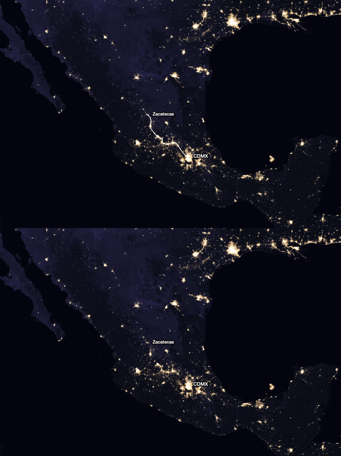
Here’s another thing you can tell from the satellite: the Camino Real! Notice this line here? It connected CDMX with Zacatecas—where the biggest silver mines were. The Spanish built forts (which would evolve into cities) along the way, to defend the silver convoys.
Mexico is super mountainous! The share of its surface covered by mountains is the same as that of Switzerland and Afghanistan!
Mexico has the longest canyon in North America: Copper Canyon. It is deeper and 4x longer than the Grand Canyon of Arizona!
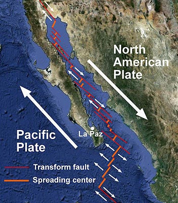
The peninsula of Baja California will eventually split and become an island.
In millions of years, though. We have time!
The two main Mexican peninsulas are exact opposites of each other.
Baja California is in the northwest, on the Pacific, and it’s thin, dry, desertic, and mountainous.
The Yucatan is in the southeast, on the Gulf of Mexico, and it’s bulky, humid, jungly, and flat.
Despite all this humidity, there are no rivers in all of Yucatan! So the natives used the water from its cenotes, big holes in the ground full of freshwater. They also used them for sacrifices (why not?)
And if you look at the cenotes on a map, you’ll notice they follow an arc. Does that look familiar? Yes, it has the same shape and age as the Chicxulub crater, from the asteroid that killed the dinosaurs 66 million years ago!
Here’s a static image:

Here’s a zoom in on the crater’s topography. You can see today the semicircular shape of a trough there:
The world’s two longest underwater cave systems are in Mexico: Sac Actun and Ox Bel Ha, both in the Yucatan Peninsula, are 380 km and 500 km long respectively.
Mexico has pink lakes in Yucatan, called Laguna Rosada / Las Coloradas.
This is common in lakes with lots of sun and salt, as pink and orange algae and bacteria adapted to an environment high in sun and salinity grow unencumbered by competitors. These algae are the reason that flamingos are pink, since they feast on them!
Mexico’s southern border has so many mountains and jungles—making it impassable—that it only has 6 border crossings for over 1,000 km of border.
For comparison, that’s 3x fewer border crossings than in Mexico’s desertic border with the US, and about 10x fewer than between countries like France and Germany.
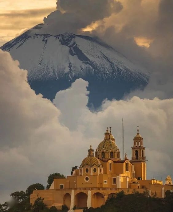
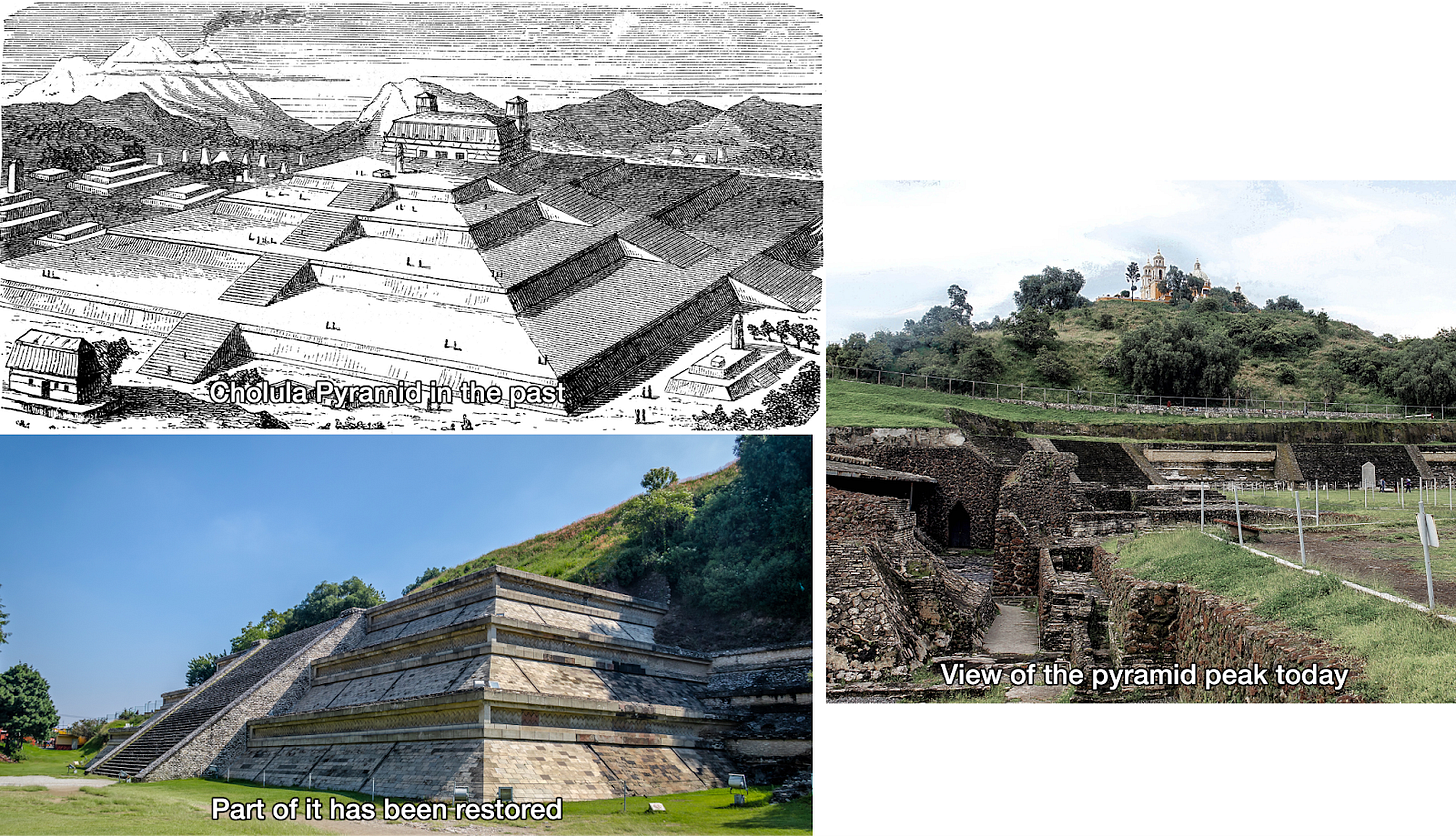
The biggest pyramid in the world is in Mexico! It’s the Cholula Pyramid, the biggest in terms of volume. To date, only part of it has been restored.
The pyramid was abandoned by the time the Spanish Conquistadors arrived.
Mayan architecture and astronomy was so precise that during the equinox, you can see a snake form on Chichen Itza:
Tenochtitlan was one of the 5 biggest cities in the world at the time. Today, Ciudad de Mexico (CDMX) has 25M people. It’s the biggest metro population in North America. The heartland, with 70 million people, is 35% bigger than the US Northeast metro area that extends from Boston to Washington DC.
Of course, as you know by now, over half of Mexico’s population lives in 8% of its land.
The largest Day of the Dead Parade in the world takes place in Ciudad de Mexico, attended by over one million people, but it started less than 10 years ago, inspired by the James Bond movie Spectre.
CDMX is sinking between 25 cm and half a meter per year! (10 to 20 inches)
Over long periods, that can sink entire buildings below the level of the street:
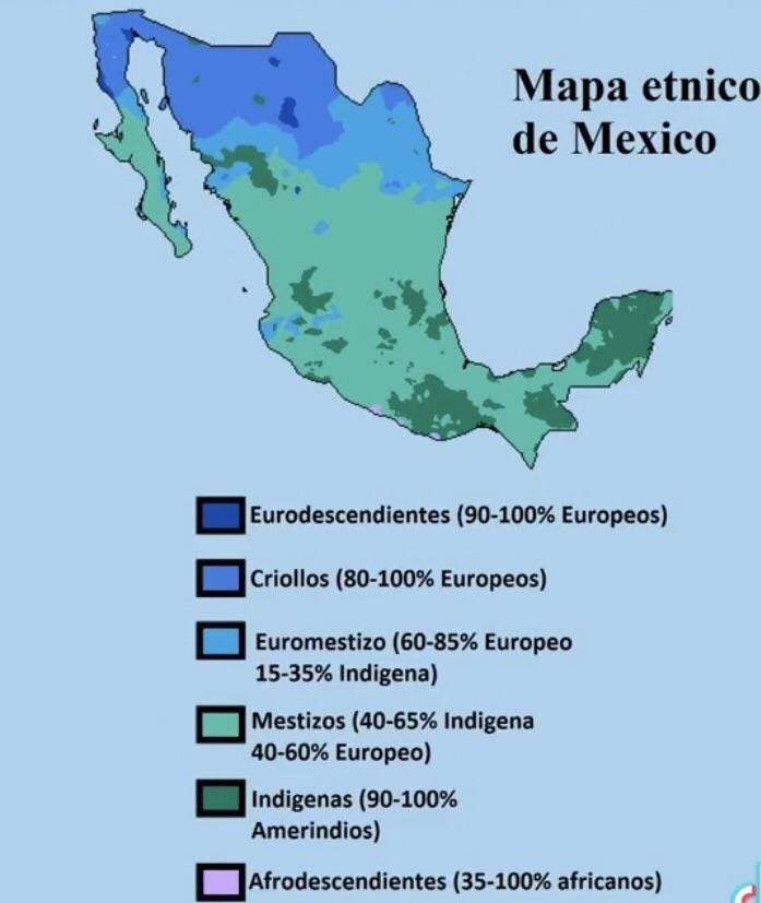
The farther north you go, the whiter Mexicans are—and vice-versa: The more to the south, the more native the population is.
Mexicans are some of the hardest working people in the world and the ones who work most hours per year in the OECD.
Mexico is the world’s biggest beer exporter
And to finish, Mexico has some of the most beautiful, diverse landscape in the world













Great article, however, Mexico did not lose Texas to the US in the 1848 war. It already split off as an indepenent country in 1836, before eventually choosing to become part of the US. Mexico did lose in 1848 most of the other land that today forms the US's southwestern states, except for the southern parts of New Mexico and Arizona, which were purchased from Mexico years later. Why? Because it provided a better path for a railroad.
I've been on a hundred or so trips exploring and surfing the northern half of Baja(which is so thin you can see the Sea of Cortez and the Pacific from certain mountains in the middle of the peninsula). Even so there's still so much more to explore, so many roads not yet taken. Mexico is huge!