Why Is 80% of Mexico Nearly Empty?
Over half of the population lives in 8% of the land
53% of Mexicans live in a contiguous piece of land that covers 8% of the country. Why?
And how does that explain the Mexican Pyramids?
Mexico’s Heartland

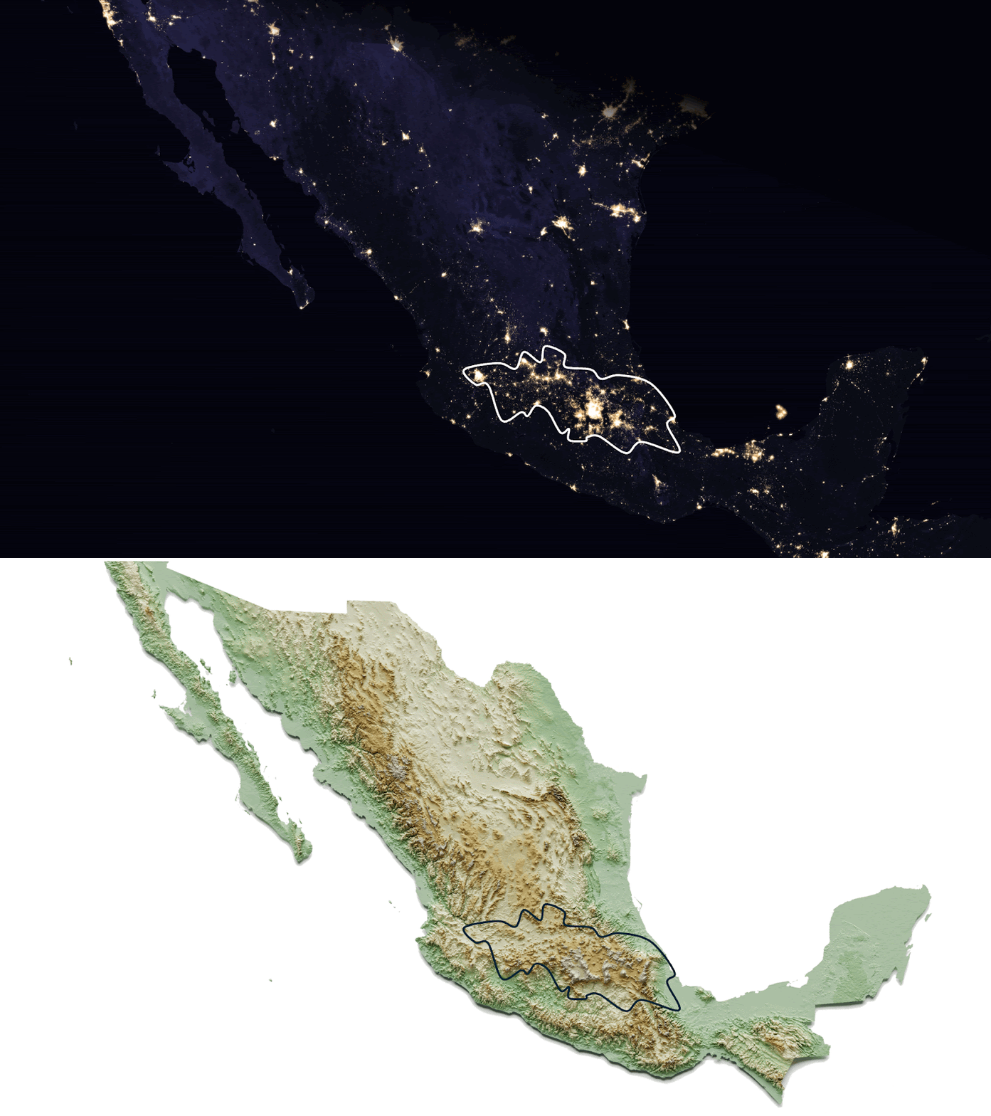
You can get an intuitive sense of it with this animation showing Mexico’s topography and night lights:
Here is the population density map.

And just to show how massive this population is, here’s the map of North American population density:

These people don’t live in the flattest, coziest part of the country. Quite the opposite!

Mexicans live in the highest altitude areas!
This is crazy! In areas like the US, Europe, or China, you find people on the plains, not in the mountains! Here’s a map of Italy’s population density vs topography (I use night lights as a proxy for population):
Every single valley is populated. Nearly every mountain is empty. The same can be seen here in the San Francisco Bay Area:
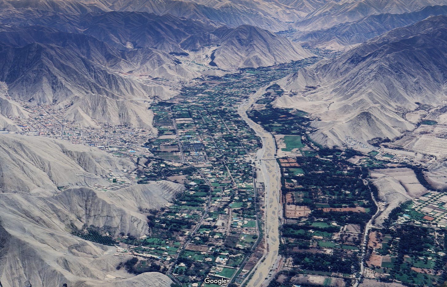
And it’s not just the most developed countries in temperate regions. This valley is near Lima—even closer to the equator:
This makes sense: Flat areas are easier to irrigate, easier to access, easier to build things on… Lower costs on everything means more wealth accumulation. In all these regions, plains societies win. Why is it the opposite in Mexico?
And this is not a recent phenomenon. Look at population density over a century ago:

Compare with how much the US has changed:
Indeed, the core of the Mexican population has been the same for over 500 years. This is a map comparing the modern heartland with the historic one before the Spaniards arrived:
You’ll notice a few things:
The Aztec heartland, and most of its empire, were in the modern heartland.
There were a couple of holes in the middle: These were states too strong for the Aztecs to beat, meaning there were other big population centers.1
The Aztecs expanded south and east instead of west to the rest of the modern heartland because… That area was already populated by other competing states that the Aztecs couldn’t subjugate!2
So the main centers of the Mexican population have been located in the same spots for centuries. Why?
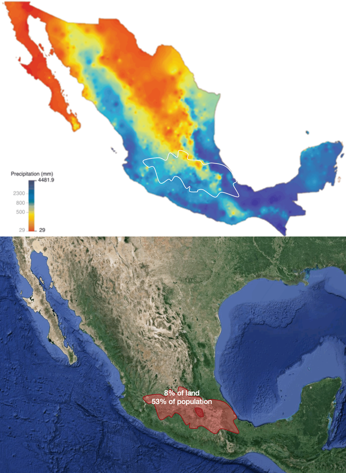
Normally, people means food, which means agriculture, which means water. But Mexico occupies very bad latitudes for rainfall—the same as the Sahara.
Luckily, it gets some rain from its oceanic influences. Here’s a map of precipitation in Mexico:
Of course, higher altitudes also mean cooler temperatures.
Thanks to its altitude, Mexico City—despite being at the same latitude as the middle of the Sahara—has this annual temperature profile:

If you combine altitude, temperatures, and rainfall, what do you get?
The heartland has some of the best climate in the entire country: Neither too hot nor too cold, with enough rain for plants to grow and to permit irrigation, but not so much to leach the ground of its nutrients and create an environment ideal for pests.
It’s not a coincidence that Mexico is one of the cradles of agriculture, with the Mesoamericans domesticating plants such as maize, beans, tomatoes, squash, cotton, vanilla, avocados, cacao, various spices, and more.
If we look at water, we must look at rivers too. Here are Mexico’s water basins: the rivers and their tributaries.

You see the four small shapes around the heartland? Those are endorheic basins. Instead of flowing to the sea, the rivers there form lakes. Let’s zoom into one of them:
Of course, this is lake Texcoco, the homeland of the Aztecs, and host of Tenochtitlan.
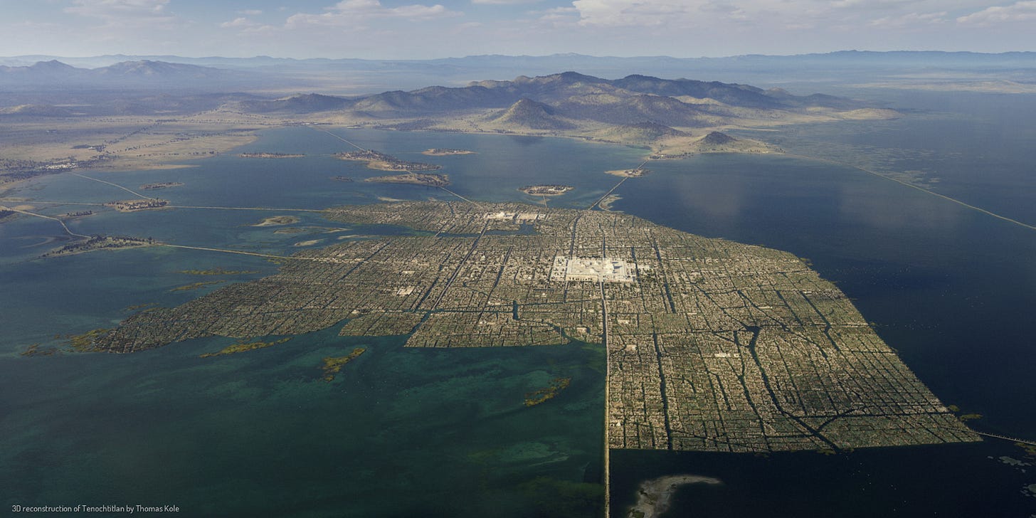
Tenochtitlan
The lake doesn’t exist today. It’s been dried up to use the water and build over the land. What you can see, however, is how:
It’s surrounded by mountains
The water from all these mountains flows to the center, where it can’t escape
But when river water accumulates for eons, it ends up forming an inland salty sea. How do you deal with salty water that prevents irrigation?
The Aztecs built a levee (“Dike of Nezahualcoyotl” on the map) to split the lake in half. The lower altitude part would accumulate all the salty water, while the upper part would accumulate the fresher water from the mountains. And which of these halves is at a higher altitude? The one where Tenochtitlan lies. This dike meant the city was surrounded by freshwater instead of saltwater, which allowed easy irrigation on the islands and surroundings, and hence agriculture.

The lake wasn’t very deep, so it was reasonably easy to pile up dirt to create new plots of land and expand the island for habitation and agriculture.
You can see the altitude today in this topographic map:

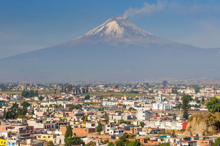
Here’s a Google Maps image of Mexico City (“Ciudad de México”, or CDMX), with the volcanoes Iztaccihuatl and Popocatépetl in the background.
Here’s a picture from the ground:
Compare this picture with Tenochtitlan 500 years ago:
Note that, similar to the Aztecs, their competitors the Tlaxcala Confederacy and the Purepécha Empire both had their own endorheic basins, along with lakes.

So, aside from a pretty ideal temperature and rain all year long, this region is irrigated by water from the mountains, which brings with it convenient sediment. Accumulation of sediments from mountains over millions of years yields high-elevation flatlands (plateaus). Water, sediment, and flatland are perfect for agriculture.
In some cases, when the water couldn’t escape, it formed lakes, which made freshwater even more accessible. It also brought fish, cheap transportation around the lake, and sometimes even salt harvesting.
It’s no surprise that, to this day, many inland Mexicans have maintained livelihoods around water.
Let’s summarize so far. These endorheic basins have:
Stable, mild temperature throughout the year
Which means few pests
Flatland
Some rain but not too much, so no leaching
A steady amount of water from rivers
Which was easy to use as it accumulated in lakes
Nutrients from sediments
But wait, we’re not done! Did you notice something else in the images I’ve shared with you so far?
Volcanoes
The famous Popocatépetl is the one active volcano out of the many that created the mountain barrier around Mexico City—the barrier that prevented water from escaping the area and formed the Texcoco lake.

There are dozens of these volcanoes around the City of Mexico… and even inside of it!

Let’s map the rest of the main volcanoes across Mexico:

And why are there so many volcanoes here? Here are the tectonic plates of the world:
As you can see, this part of the world is at the meeting point of the North American Plate, the Cocos Plate, the Pacific Plate, the Caribbean Plate, and close to the Nazca Plate. If you zoom in:
Further north, the Pacific Plate is moving up, creating friction with the North American Plate—and hence the famous earthquakes of the US West Coast. But here, the Cocos Plate is going under the North American Plate. This creates volcanoes:

If you think about it, the Aztecs were surrounded by volcanoes that could erupt at any time and destroy them. But these volcanoes were also the source of the water they needed to survive. If you had lived there centuries ago, how much do you think you’d venerate these volcanoes?

Why does it matter that there is an arc of volcanoes here? If you’ve read the Java article, you already know:
I know! Your eyes are telling you something but you’re not sure, and now you can’t contain your excitement! Neither can I. Let’s zoom in on Mexico immediately:
Ooooh, what’s that purple area in the middle? Andisols you say? Is that a Decepticon? No! It’s the second most fertile type of soil there is!3
So if you combine the locations of climate, volcanoes, andisols, and population, what do you get?
They’re all in the same place!
In summary, the Mexican heartland contains over half of the Mexican population in a tiny area because:
The Cocos Plate subducts under the North American Plate
This raises the area, and also creates volcanoes
The raised area allows for a mild, constant temperature through the year despite being in the tropics
It also allows the mountains and volcanoes to catch rain carried by the winds from the oceans
This water flows down into rivers, which carry fertile sediments
The soil is extremely fertile anyways because it’s volcanic
The water gets trapped in endorheic basins, forming lakes that could be used for water, transportation, fertile soil, and irrigation
The sediments also flatten the land
Mild temperature, water, flat lands, and fertile soils mean an outrageously high land fertility
With this terrific environment, Aztecs could cultivate up to 7 harvests per year! No wonder they already had a huge population centuries ago—Tenochtitlan was among the top 5 most populated cities in the world, with around 200-400k people!
Today, we can’t see Lake Texcoco anymore. But the conditions that made it so productive still exist, they’re still shared across the Trans-Mexican Volcanic Belt, and they’re the reason why most of the Mexican population lives in the concentrated heartland to this day.
The closest hole to the Aztec Heartland represents the Tlaxcala. The other two are the Metztitlan and Teotitlan.
Like the Tzintzuntzan Kingdom and the Purepecha Empire.
The most fertile is mollisols, which are also common in Mexico as you can see (dark green), but in areas that don’t receive that much water, which made them unproductive for most of history. Unfortunately, the area that receives most rain has inceptisols, which are not very fertile.










Tomas, the passion of your writing is infectious, and the education this piece provides is just amazing (as with the others I’ve read)! Thank you so much for what you do. More!!!
BTW, there is a mini-series called "Hernán", in Spanish and Nahuatl (subtitled), about Cortés and the Spanish conquest of the Empire. It's pulpy but brings Tenochtitlan to life wonderfully. And it's quite a story.