What China Wants and Why
Why is China increasing its assertiveness towards Taiwan? Why the Belt and Road initiative? Why the oppression of Uighurs? Why the occupation of Tibet? Why the creation of islands in the South China Sea?
It all comes from the Hu Line.

The Hu Line
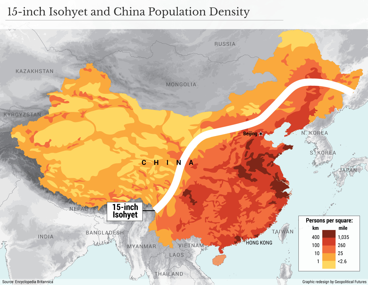
94% of China’s population lives on 43% of its land, east of that line.
This is a detailed map of China’s population density:

Why do so many people live east of the Hu Line?
This is a map of rainfall in China.
The white line is called a 15-inch isohyet, which means it gets 15 inches of water per year. East of that line, it gets more water. The wettest areas are the most populated: with more water, they have more fertile lands.
The land east of the Hu line is also the flattest.

You can clearly see a line of mountains (dotted grey on the map). The east of that line is mostly flat, the west is mountainous.
Luckily for China, based on its latitude, it gets winds from the east (trade winds), loaded with water from the ocean.

And the ocean current comes from the south, so water is warm, and warms up the coast.

All of this warmth and water and flatness means there’s lots of rain, and the eastern part of the country is really fertile.

Meanwhile, the west of the country is just mountains, formed by all the tectonic plates hitting each other, especially the Indian and the Eurasian ones, forming the Himalayas.
As the Indian plate hits Eurasia, it forms the Himalayas, the Tibetan Plateau, and all the mountains of China’s west.

Because the Himalayas are so high and extended, they stop a lot of water from the clouds. All the water that comes from there forms huge rivers, each of which formed distinct civilizations: Indus (now Pakistan), Ganges (now India), Irrawaddy (now Burma), Mekong (now Thailand, Laos, Cambodia and Vietnam), and the Yellow, Yangtze, and Pearl rivers (China).
But why do mountains stop in a line parallel to the coast? Why not continuing all the way to the coast, for example?
That line is called the North-South Gravity Lineament, and it’s caused by the Pacific tectonic plate.

We’re not sure how it works, but apparently the Pacific plate going below the Eurasian one for millions of years destroyed the rocks above it and flattened the land.
So the Hu line (dividing the country by population), the 15-inch isohyet (dividing it by rainfall) and the North-South Gravity Lineament (NSGL, dividing it by plate tectonic subduction) are nearly the same.
Ok, let’s summarize: what do we have?
The Indian plate hits the Eurasian plate from the south, forming mountains in all the Western part of the country.
The Pacific plate goes below the Eurasian plate on the east, forming flat lands there.
The winds from the Pacific Ocean, warm and full of water, go above the flatlands in the east, but are stopped by the mountains in the west. The result is lots of rain and massive rivers in the east, and very little in the west.
Lots of flat lands with lots of water means lots of agriculture, which means lots of people.
So the east is hyperpopulated, and there's barely anybody in the west (in comparison).
We’ve made sense of China’s population now. They’re all in the east. But why are most of these Chinese people in the east of the Han ethnicity?

Of China’s 1.4 billion people, 94% are Han, and their distribution follows nearly perfectly the Hu/15-in isohyet/NSGL line. This is surprising, especially if you compare it to India, and its diverse ethnicities. Why is China’s population so uniform?
To understand that, we need to look at history.
A Brief History of China
You can see how the cradle of the Chinese civilization is in that coastal plain in the east, called the North China Plain. This is where the Han come from.
This is also where both of the biggest Chinese rivers arrive to the sea.
These two things are interconnected: so much water and so much rain means lots of sediments, which means more land, and very fertile land at that.

Naturally, that region has the best arable land.
So here’s what happened with China:
The biggest, flattest plain with the most water and biggest rivers could feed—and birth—the most people. The Han were probably extremely populous millennia ago in comparison to other peoples around them.
Because the land was flat, communication and trade there were also the easiest, so this region was also the richest.
This is why the first kingdoms appeared there 3000 years ago.
Naturally, with more people and wealth, the Han conquered the regions surrounding them.
Once the heartland was consolidated, the first land to see the expansion of the Han was to its south, since it’s not that mountainous, so it was more fertile, and hence richer. It was also easier to access.
The Han conquered little by little all the eastern part of China. It took 1000 years, from ~1000 BC to ~1 AD, to fully unify it. By the time of the Romans, the conquests were mostly completed.
It took another 1000 years, from ~1 AD to ~1000 AD, for the Han to consolidate, reproduce, grow, and develop the technology that would allow them to expand further, outside of the eastern half.
They spent the following 1000 years, from ~1000 AD to ~2000 AD, expanding and consolidating the periphery.
And this is why the east part has so many Han: They started in the North China Plain. Thanks to its great land, they could reproduce and conquer the surrounding lands, and the closer these lands are from the North China Plain heartland, the more Han there are. Then, over the centuries, they further reproduced and absorbed new regions.
Comparing China with India makes the contrast really remarkable. In China, the Yangtze and Yellow rivers from the Himalayas arrive to the sea at the same plain, which produced a massive heartland. Meanwhile, in India, there were always two distinct Himalayan rivers, the Indus and Ganges, which have caused two heartlands. What if the Yangtze and Yellow rivers had been separated by a big mountain range? China would probably not exist today, and if it did, it would be much less homogeneous.
Now we’re equipped to understand why China has behaved the way it has.
China’s Game of Thrones
For thousands of years, the first priority for China has been to protect the North China Plain heartland. Its second priority has been to protect the eastern half. Everything in China’s history can be understood as a consequence of these priorities.
Another way to put it: China is the Han, and the only thing they care about is protecting the Han. So looking at ethnicities gives you a sense of how they need to treat their borders.
The pink, orange and yellow areas above can be best understood as buffers for the brown area.
The heartland has always been threatened by the nomadic tribes that live in the north. These tribes weren’t just small groups on sporadic raids. Some were dangerous enough to conquer and rule China: the Mongols ruled for a century, starting in the 1280s, and the Manchus for nearly 250 years, starting around 1650.
China’s solution has been two-fold: The first was the Great Wall of China.
You can see how it begins just at the border of the North China Plain. Its construction started about 1000 BC and it was built further and further for 2000 years.

This slowed down threats but didn’t eliminate them. So the Han expanded northwards to take over the bothersome—from their point of view—tribes.
It took as a buffer Manchuria (the plain in the northeast) and a big chunk of the mountainous area in the north.
In the west, you can see there’s a long, flat(tish) path. It’s the path followed by the Silk Road, the only easy(ish) connection between China and the rest of Eurasia. The extreme west is the region of Xinjiang, inhabited mostly by Uighurs. Because of their closeness to Central Asia and the northern steppes, the population there is mixed, about half-Turkic and half-Han.
Because it’s such an open area, it’s not so easy to defend from invasions there. The answer for China was, again, to invade it and control it as a buffer.
The exact same thing happened just south of Xinjiang: the Himalayas and Tibet are such a formidable barrier that it would be very hard for a big military to invade, control, and logistically move millions of troops in that area. Owning the Tibetan plateau made it impossible for India to ever even consider it. So Mao’s China invaded it in the 20th century.
The same thing happens at the border with Burma and Laos: China has a buffer there that is mostly full of mountains and jungle, so it’s very hard to invade. It’s safe.
What isn’t as safe is the border with Vietnam:
Which is why the northern part of Vietnam has been Chinese in the past, and why China has invaded Vietnam more than a half-dozen times, most recently in the 1970s.
The other part where China is not safe is on the coast. Until the 19th century, China was very secure there. Nobody had ever invaded it from the sea. In fact, China had a huge navy at some point, but without enemies to fight, it just abandoned it.
Then came the Europeans through the sea—especially the Brits—who forced China open to their trade and humiliated it through successive wars. One century later, it would be the turn of Japan, who invaded first Manchuria and then the most valuable Chinese land on the coast.

The existential threat of having two successive invasions to their heartland has focused the Han single-mindedly on protecting the coast.
Understanding China’s Policies Today
All the needs described above explain China’s policies today: they’re all aimed at protecting the Han heartland at all costs. On land, the goal is to neutralize everything that’s not Han (in brown).
The Northern Realms
It’s secure in the north with its buffer zone. Mongolia and Siberia are poor, sparsely populated, and horsemen are not a threat anymore. No need to further invest there.
The Western Realms
Xinjiang and Tibet have a role of buffers against Central Asia (including Russia) and India. That’s why China will never give them independence and will use time to strengthen them as buffer regions.
It’s why China has built internment camps in Xinjiang, is eradicating Islam, and floods the area with Han settlers.The more Han it is, the stronger a buffer it becomes for the heartland.
We haven’t heard the same with Tibet, probably because it has been a region of China for less than a century, because it would be very hard to use it to invade China, and because it’s not as strategic—as we will see in a moment. But I wouldn’t be surprised if, at some point in the future, the Han started a systematic Han-ization of Tibet.
The Southern Realms
China is unlikely to invade Vietnam again, a country with 100 million people and which beat China 50 years ago in a war. But that doesn’t mean China is comfortable with the exposure of its southern border with Vietnam. I wouldn’t rule out more military buildup there. I wouldn’t be surprised either if there were policies to overwhelm the population at the border with Han culture, or skirmishes to get the military upper hand in case of a threat.
Overall, most of China’s land borders are pretty secure now, or are in the process of becoming secure. The biggest threat now comes from the sea.
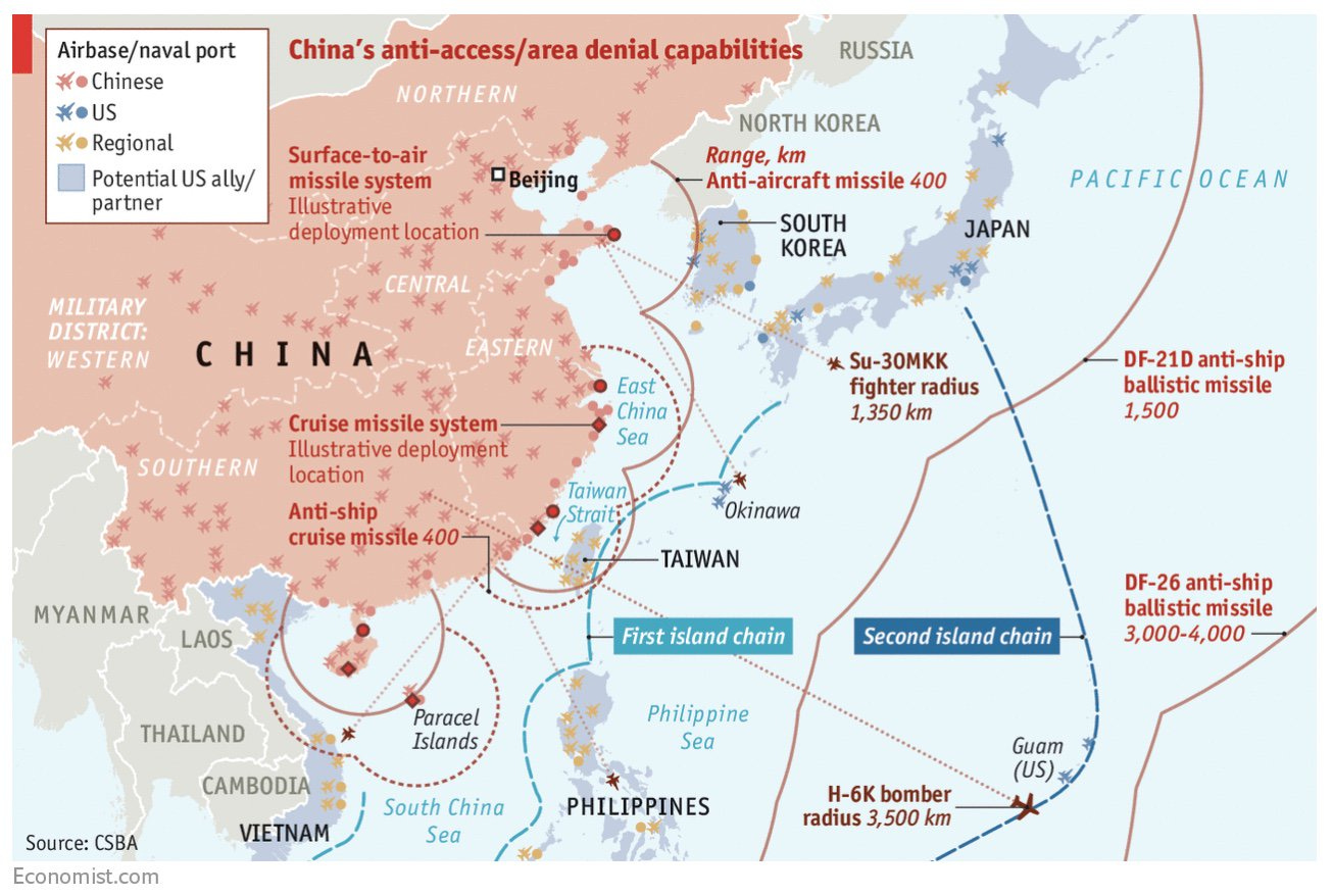
China is surrounded by foes on its coast. This is why it works so hard to expand its territorial waters.

The goal is to have as much control of the sea as possible, to thwart any potential threat coming from there.
It’s also why China increases its assertiveness towards Taiwan, and why we can expect it to further escalate its aggression to annex it.
When preparing for a war, however, it’s not enough to protect against direct aggression. You also need to secure your supplies. And there, unfortunately for China, it’s exposed.
To its east, the access to the Pacific could be blocked by Japan, South Korea, and Taiwan.
To its west, the access to existing trade routes goes through the Strait of Malacca, controlled by Malaysia, Singapore, and Indonesia. It could be easy to disrupt.
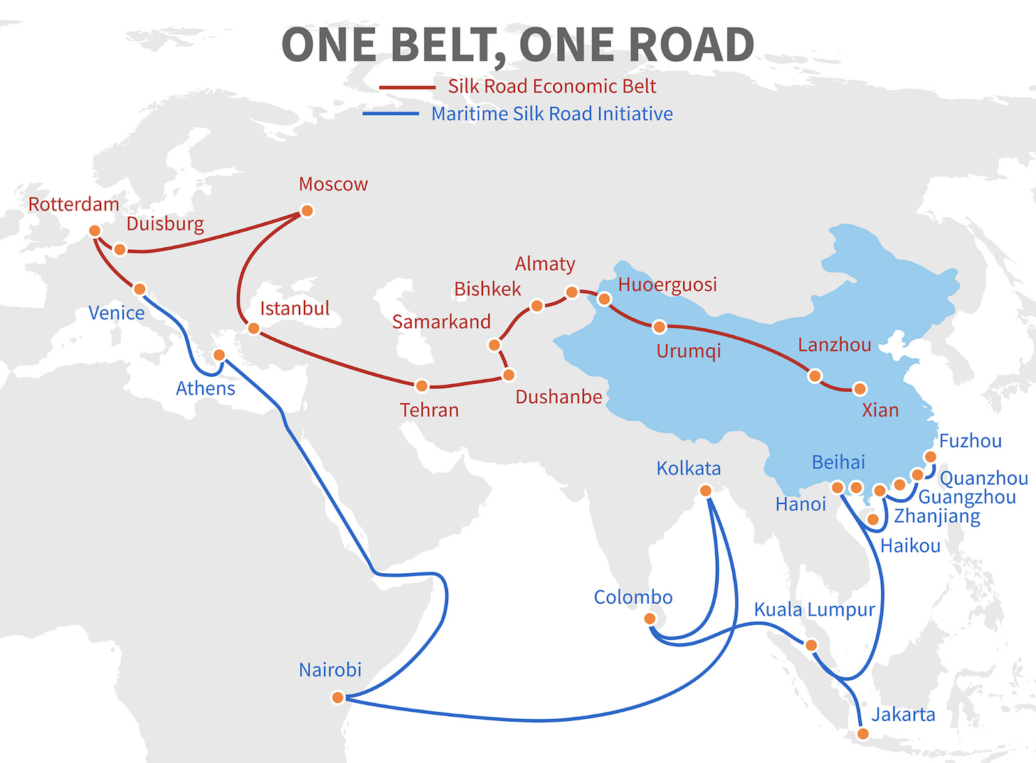
And hence the Belt and Road initiative.
China can reduce its exposure by strengthening the maritime pathway, and by hedging its risk with an alternative land route—which goes through Xinjiang, making it that much more strategic, and justifying further in their eyes the mistreatment of Uighurs there1.
It’s also why, as the US withdraws from Afghanistan, China is likely to invest heavily in controlling the area, at least so that the Belt and Road initiative is not at risk from warring sides there.
Takeaways2
China is the Han, which means the eastern part of the country.
It is so because plate tectonics made that area flat, humid, and served by huge rivers which made land fertile and trade cheap.
The rest of China is just buffers for them: the northern mountains, the trade and invasion corridor through Xinjiang, the Tibetan Plateau, the Vietnamese border, and the China and South China Seas.
The one buffer that is not secure is the sea, which is also the main way that China has been invaded over the last 200 years. So China is most concerned about its sea now.
To protect its seas, it wants to annex Taiwan and increase its maritime buffer, by enlarging the share of the South China Sea that it controls.
But that protection will never be perfect, so it hedges its risks with the Belt and Road initiative.
What does all of this mean for the future of China? What policies will they follow in the coming years? Why? What will happen with the Belt & Road initiative? Taiwan? Xinjiang? Trade? Internet companies? Authoritarianism?
I am writing a follow-up to this piece on the future. Subscribe now to receive it!
This is also why overwhelming the Tibetans is less of a priority. No belt-and-road there.
I can’t resist the comparison with Game of Thrones. The east is King’s Landing. The Kingdom of the North is the nomadic tribes, the kingdoms in the west are like Casterly Rock (mountainous but with valuable resources). The south is Dorne. But, really, the threat came from sea invaders from another continent in the east.


The historical dangers to China are really internal, I believe. The "Mandate of Heaven" is earned and kept by the ruler(s) who are strong enough to enforce policies and activities that require a central governing authority that can, for example, raise huge levees of laborers (in the old days) to keep the big rivers within their banks. Some parts of the Yellow River run 50-60 feet of the surrounding land owing to the steady deposition of silt that gives the river its name. The banks of the river are really huge earthen levees built and maintained through the authority of the central government. When the ruler(s) become corrupt or incompetent and catastrophe ensues, hundreds of thousands can and have died. The Chinese have never been good at projecting power beyond their borders. The Europeans made inroads in the 1800s because of Chinese weakness. The Communists are just the latest in a parade of internal conquerors who claim the Mandate over the weakness of the Nationalists who had completely exhausted themselves fighting the Japanese. Now, the world is paying a terrible price for the Chinese hubris and overreach with the Corona virus experiments gone awry. This release of such a monstrous killer on the people of the earth -- including China -- not only makes Chernobyl relatively inconsequential as an example of deadly incompetence, but it is a shadow that will never leave the Chinese people. And soon, the inevitable demographic decline will begin taking a toll on the plans of an expansionist overlord class of some 80 million CCP members in a country of 1.4 billion that is growing old before it got rich. It is only a matter of time till the Mandate passes from these terrible men.
China will hit a wall soon and suddenly. 1. Their growth was fueled by vast numbers of young people moving off the farm. They are running out if those. 2. They have built so much infrastructure so fast that it will all start to need repair & replacement at the same time. 3. They are building a vast military, which takes wealth away from productive uses. 4. They will need more social spending since there are a higher percentage of elderly people than before, & familes can't support them. 5. They are starting to regulate industry more because people won't tolerate the pollution & bad working conditions. In other words, the reckless growth of recent decades will come to an end. The U.S. has the same problems, but I think they will hit China harder.