Why Is Pakistan Drowning and China Drying?
Have you seen the videos?
When the Pakistani minister for climate change said that “literally, a third of the country was underwater”, I thought she didn’t mean “literally” literally. But she did.

It’s affecting a whopping 50 million people. How come such a mountainous country as Pakistan is submerged under water? We hear this is due to climate change, and that Pakistan is one of the countries most affected by climate change. But why?
Meanwhile, not too far away, China is having one of the worst droughts in history.
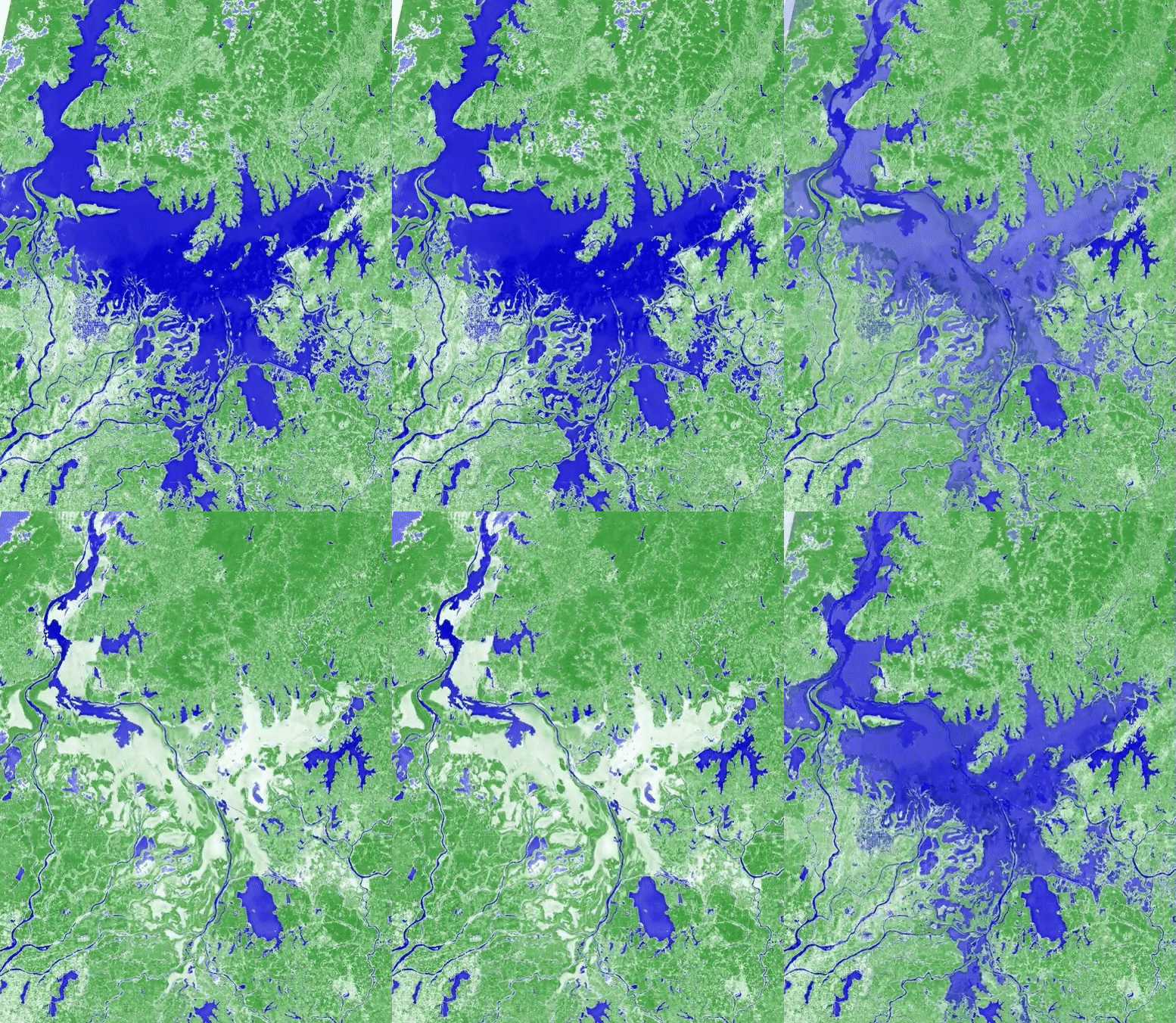
Satellites give us both Pakistan’s floods and China’s drought.
These events are two sides of the same coin. To understand, we need to go to China first.
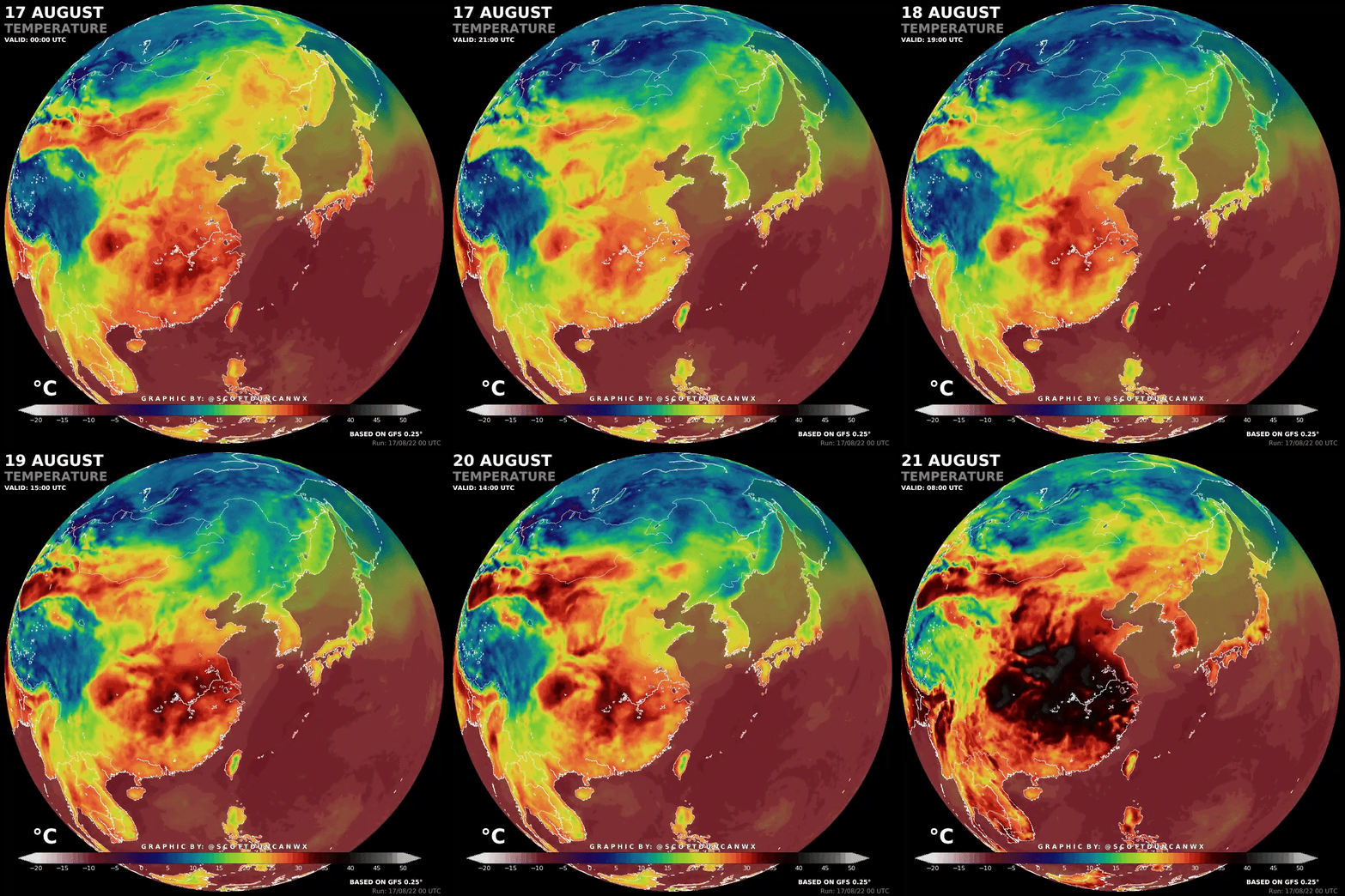
China’s Heatwave
It’s unprecedented.
The heat is causing a drought, which also reduces hydropower, which in turns reduces the energy available to seek relief from the heat with AC.
Unsurprisingly, this heatwave is caused by climate change.
It’s no surprise that the rest of the Northern Hemisphere is suffering from the same heatwave.
Records have been reached in the US, India, the UK, Spain, France… Why this dramatic increase, when we’ve only increased global temperatures by 1.2°C since the beginning of the Industrial Era? It’s a matter of distributions.
This is the normal distribution of temperatures, which humans have evolved with, with somewhat equal events of extreme heat and cold. But if you shift it just a little towards hotter temperatures:
This is what’s happening across the Northern Hemisphere right now. You increase heatwave events manifold. In fact, 90-fold.
But then why is it causing these floods in Pakistan? And why not in China?
Pakistan’s Floods
We’re hearing the cause is a historic monsoon.
Are monsoons the only culprit?
Why is it happening at the same time as a global heatwave?
And why is it impacting so many people?
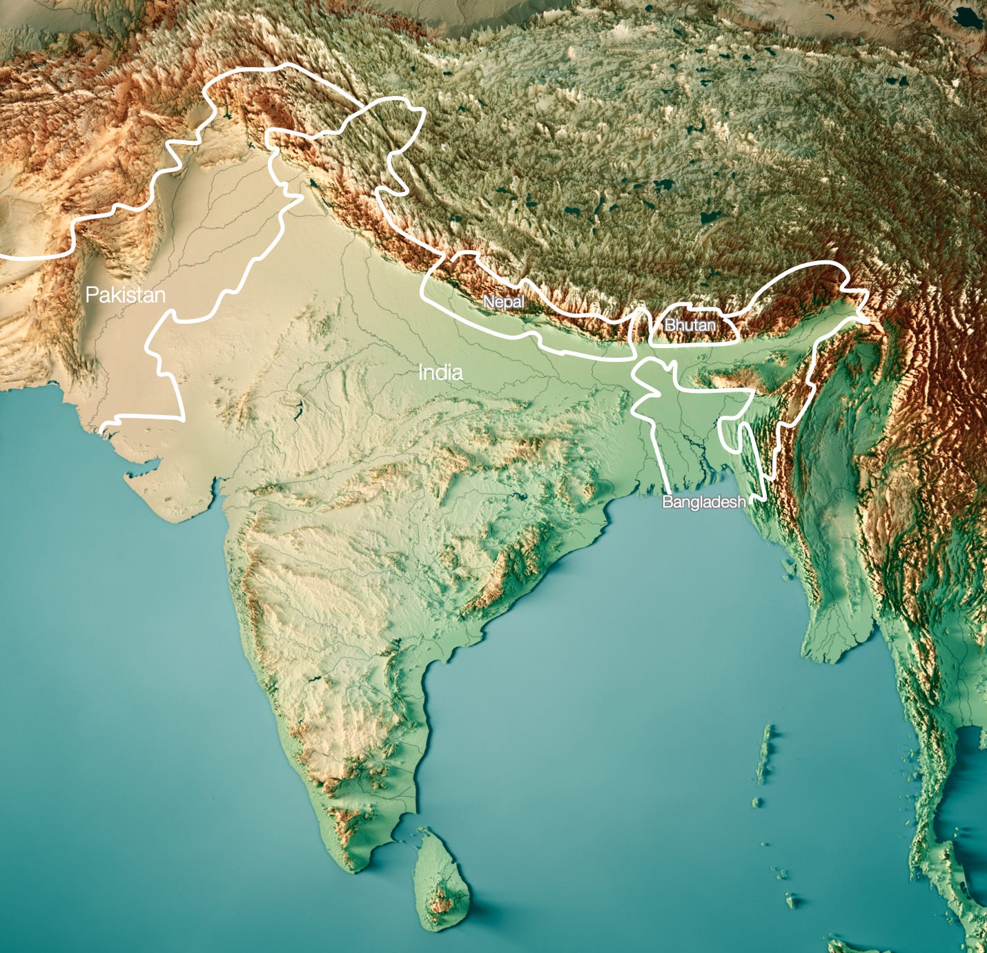
To understand this, we need to understand Pakistan’s geography.
Pakistan has two things: very high mountains, and a very flat plain.
The plain, in turn, is either desert or the Indus Valley.
The Indus Valley is where the population is most concentrated. You can easily tell by just looking at the map of nightlights:
So when the Indus floods, it does so on the most fertile areas of its valley. The most fertile areas are also the most populous, and so a big share of Pakistan’s 220 million people is affected.
So why the floods? Why is the monsoon so aggressive this year?
We need to understand the mechanics of the monsoon.
The Monsoon in the Indian Subcontinent
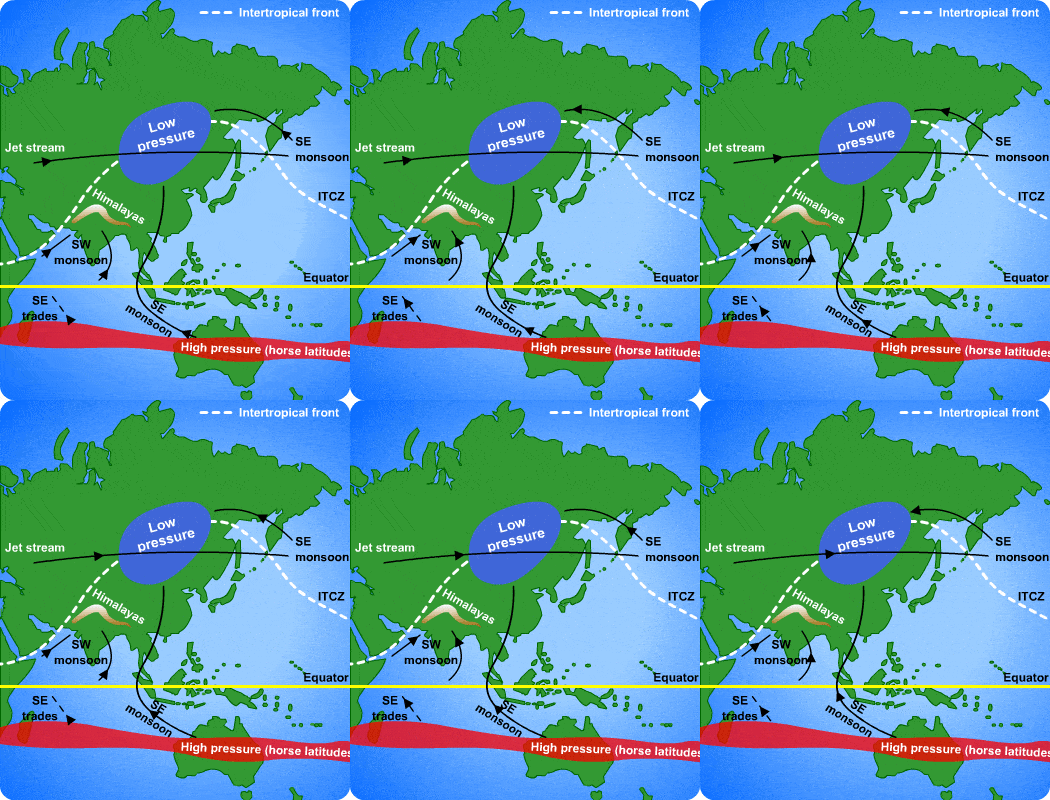
The monsoon rains start in June and cover the entire Indian Subcontinent by August. These are winds coming from the Indian Ocean, from the southwest, loaded with humidity, which then condensates and falls on land. Later, during the winter, the direction is inverted: Winds go from the land towards the sea, from the northeast towards the southwest.
But why do these winds exist? They don’t correspond to the wind patterns of the rest of the Earth.

It’s because, unlike most of the rest of the Earth, the Indian Ocean only occupies the southern hemisphere, while the Eurasian continent is on the north.
During summer in the northern hemisphere, the Indian Ocean heats up close to India, which causes water to evaporate. But the land heats up much more than the water. Hot air goes up. That empties the air at the bottom, and the colder, more humid air from the sea then goes on the land.
The humid air enters the land, rises as it’s heated, and there it meets colder air that condenses the water and it falls.
So when Eurasia burns with a heatwave, all of its hot, dry air travels up, which leaves an emptiness1 that sucks up massive amounts of humid air from the Indian Ocean onto the continent.
The hotter the heatwave:
The more humid the air from the sea will be.
The more the hot air from the land will rise.
The more it will suck up the humid air from the sea.
The more water will be unloaded on land.
So that’s why a historic heatwave in the region leads to a historic monsoon.
But that’s not all. There are two more factors at play, both linked to this:
The Himalayas

The Himalayas2, of course, are created by the Indian Tectonic Plate hitting the Eurasian Plate.
The Himalayas are massive, so they stop the water due to the rainshadow effect we’ve discussed multiple times in this newsletter:
Here’s a video that gives an intuitive sense of the effect:
In the Himalayas, most of the humid air drops its water on the Indian Subcontinent side of the Himalayas, not on the Tibet side, which is why China is seeing a drought and Pakistan a flood3.
There’s one last element: the glaciers.
Pakistan has 7,000 glaciers, the most of any country outside of the polar regions.
Historic heatwave means historic glacier melting, which means historic floods.
Takeaways
The Indian Ocean and Eurasia are special in that it’s the only place in the world where the entire northern hemisphere is land and the southern part is sea.
Their respective tectonic plates hit each other, creating the biggest mountain range on Earth.
Climate change causes extraordinary heatwaves, including one currently in the Northern Hemisphere.
The heat melts the glaciers from the mountain ranges.
It also loads sea air with water.
It also raises the hot, dry air from the Eurasian plain, which draws in the wet sea air.
The mountains stop the water from the humid air, and this forces it to fall in what we call the monsoon.
The water from the glaciers melting plus the water from the monsoons combine to flood the Indus Valley.
These same reasons make the Indus Valley fertile, and hence densely populated.
As a result, the Pakistani population gets hit with massive floods when there are heatwaves like that at the end of the summer.
Meanwhile, China doesn’t get its water from the Indian Ocean monsoon: These winds are stopped at the Himalayas and don’t penetrate much into Tibet. The Chinese monsoons come from the Pacific and happen earlier during the summer, so this heatwave is causing drought rather than rain.
AKA “low pressure”.
It’s not just the Himalayas. It’s all the mountain ranges around Pakistan: Mainly the Hindu Kush, but also the Tibet area behind the Himalayas. I just call it the Himalayas for simplicity: It doesn’t change the idea, and most people don’t make the difference in their brains.
China does get a lot of water from Tibet. Most of its rivers, including the crucial Yellow and Yangtze Rivers, are born there. But it’s substantially less than on the Himalayas side. Also, that water doesn’t come as much from the southern monsoon winds and rains, but rather from the monsoons that come from the Pacific and drop their water through the continent, including Tibet.


Interesting. One effect isn't mentioned, which contributes to the problem of China further: When air is loaded with evaporated water it contains also the energy that was necessary to change water from liquid to a gas.
When water condenses while the air gains height climbing the mountains that energy is released again as heat, it keeps the air at the relative dewpoint temperature (which depends on humidity and pressure). As that heated and dried air then flows down on the lee side of the Himalayas it gets under pressure again and heats up as the energy can't be stored as water vapor again - the water was left behind. The air is thus even way hotter than it was when on the pakistani/indian side of the ranges.
It would be worth investigating the impact of insufficient water reservoirs on mass flooding in Pakistan. For example, India does not get regularly flooded to the same extent despite having more rivers than Pakistan and all of them originating from a high gradient somewhere in Karakoram or the Himalayas like Pakistan. There are floods in India almost every season like Pakistan but never to the extent of 1/3 of the country under water. I doubt even 1/10th. The duration of the floods is also not as long as Pakistan where it can often last several months since the only egress available is the Arabian sea. The current floods are the second mass incident in recent years. The 2010 floods affected more than 20 million people. Are there geographic/topological reasons that prevent mass, long-running floods in India? Or merely a lack of investment in a reservoir network.