Why Is Madrid the Capital of Spain?
And how did it grow from a backwater to a global capital?
This is a new article in the series about cities, which includes Transportation Technologies (parts 1, 2, 3, 4, 5, 6, and 7), The Rise of Cities (Pittsburgh, Chicago, New York, Québec, Kansas City, Minneapolis-St Paul, How to Create a New City, Interview with Mark Lutter), and Urbanism (1, 2).
So far we’ve mostly delved into examples of cities in the New World because their emergence has been well documented, but recent research allows us to do the same with cities in the Old World as well. And few in Europe have a story as weird as Madrid’s.

Most of the capitals of countries around the Mediterranean have existed for thousands of years. In fact, Romans didn’t found the majority, but rather further developed the biggest and best positioned ones. London is an exception because it required a bridge that locals couldn’t build.

Indeed, bridges are a common theme in European capitals:
Nearly all the capitals have bridges because they have rivers.
But can you name Madrid’s river?
No?
You sure?
Fret not. Madrid’s river is puny. It is weak. It is an affront on capital rivers. It is a feeble stream.
Don’t let the overdone bridges and embankments fool you. Notice instead that bridges are so low that ducks have a hard time passing below them. The “islands” in the middle are sandbars. Why do Madrileños allow these sandbars to form? Because there’s no point in clearing them: The only thing that navigates the Manzanares is its inferiority complex.
But Spain is one of the oldest countries in Europe. How is it possible that its capital is so young and has this unacceptable river?
And we’re not done with the weirdness. When Madrid became the capital of Spain in 1561, it was not the biggest city in the country. It was not even the 2nd biggest city, or the 3rd. It was the 10th!
What is going on?!
To understand this, let’s recap how big cities generally emerge, and how Madrid’s path was different.
How Big Cities Form
In Why Some Cities Thrive, I explained the basic way that cities end up becoming big:
Small towns form around rivers for water and irrigation
On positions that can be easily defended militarily
The ones that grow big are on crossroads, because they are perfect spots for markets
Markets create wealth, which attracts people, who increase trade, and so on and so forth
More infrastructure is built, further increasing the city’s trade and entrenching its strength
Usually the river is one of the roads
Frequently, these cities are at the confluence of rivers, which gives them two natural communication channels for free—the rivers, which don’t need much infrastructure to be used
Many others are on the coast, providing access to the sea, and hence trade with other coastal cities
This is evident when you look at a population map of France. You can follow the rivers because they concentrate population, and their confluences have big population nodes—cities.

Then, the bigger the city, the more services it has, the more specialization, hence more trade, more wealth, more investment in infrastructure, more commerce… in a fantastic loop of network effects.
Ultimately, this means that the bigger the city, the bigger the city. It starts attracting people from its surroundings, absorbing their populations. This is how we end up with a fractal pattern of cities all around the world.
This is a pretty Darwinian way for cities to emerge and grow, and means that those with strong initial advantages end up surpassing all others.
And then you have Madrid, like a peacock flouting evolution.
Of course, peacocks have an evolutionary advantage that is not straightforward. Those tails don’t increase their odds of survival from predators. In fact, they make it harder, and that’s the point. By showing that they’re still alive despite those huge tails, they prove to the females they must be strong.
In the Head of Philip II
The guy who decided Madrid would be the capital of Spain was Philip II—one of the most powerful kings the country has ever had, who ruled in the 1500s.

Until the mid-1500s, Spain didn’t have a fixed capital. The king would travel with an itinerant court. So what did Philip II have in mind when making the decision?
Of course, he had his country in mind:

There are two things you can immediately notice about Spain:
It is surrounded by seas
It is covered by mountains
The mountains have severe consequences for rivers:
All these mountains meant many rivers separated from each other. That made them smaller. It also made them unnavigable, so they couldn’t be used for trade.1
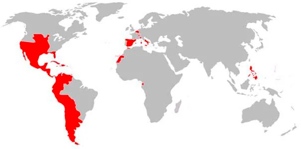
And that’s just Spain in the Iberian Peninsula. Philip II also had his empire:

And zooming into the European part—the richest at the time—this was the Spanish empire:

The Kingdoms of Castile (“Castilla” in the map above”) and Aragon were very powerful
Aragon controlled the eastern Mediterranean, including southern Italy
Castile controlled America
And then there are the Low Countries (part of present-day Netherlands and Belgium)
And some other stuff like Milan
Now put yourself in the shoes of this guy. He must have a capital that is as close as possible to his Iberian possessions, his American possessions, his Italian possessions, and his Dutch possessions. The Iberian peninsula is a natural place to do it, since it’s central.
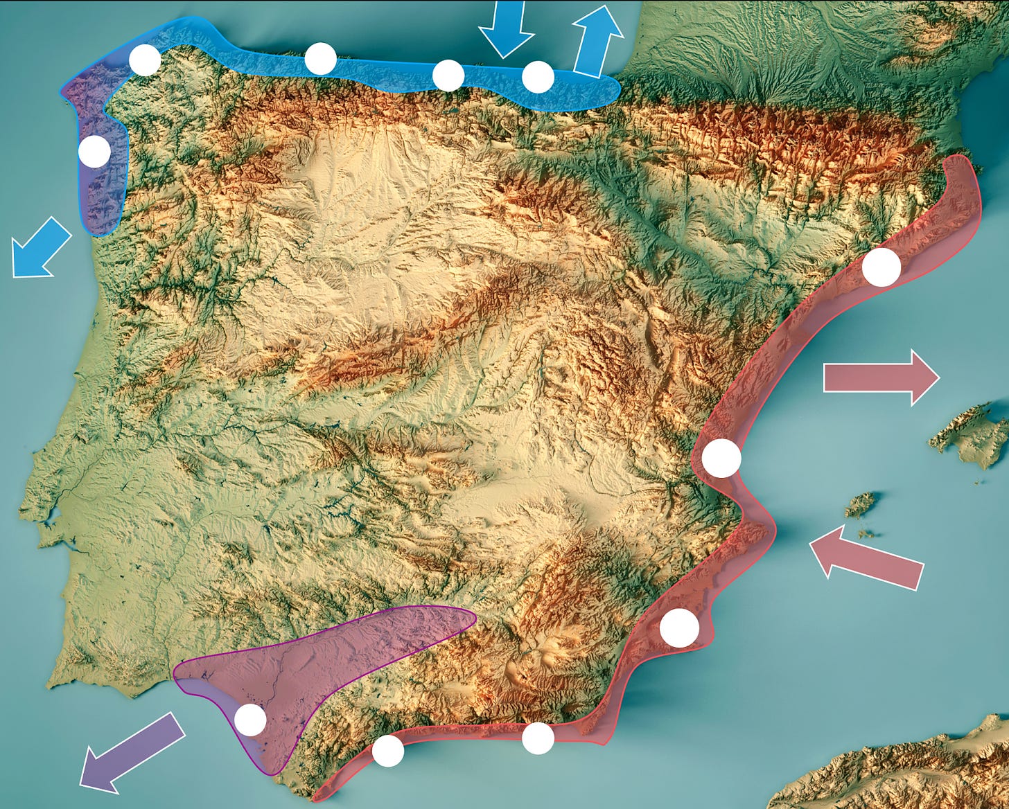
But where exactly? This map shows Spain’s topography and Spain at night. The lights show where people are. The patterns have changed since Philip II, but not too much.
Notice how Spain has all these islands of population on the coast? Wherever there’s a coastal plain, there’s a population center. And since there are mountains everywhere, all these coastal plains are secluded from the rest. In effect, most Spanish coastal cities were islands.
Then, each coast had a different focus:
The east coast was focused on its possessions in Italy, and on defending itself against the Berber attacks from Africa.
The southwest coast was focused on the trade with America.
The northern coast was partially focused on America, but also on the Dutch possessions and the wars with the English.
Philip had to connect all these coastal areas, plus the three big internal regions: the two plateaus of Castile and the Ebro Valley.
This is why the court had been itinerant until then: There were so many possessions, and they were so disconnected that the king had to travel around to make sure things were running smoothly.
This is a fun puzzle. Where would you put the capital in this situation?
The most natural place is the one most connected to all these regions.
Surprisingly, the coasts were not that well connected. Isn’t connection the point of having ports? But in this situation, having ports wasn’t enough:
The eastern coast was hounded by Berbers, so there wasn’t much traffic.
The northern coast was hounded by the English.
All of these coasts are peripheral, exposed to different seas, so traffic between them is not huge.
This is why the best connected city with coastal access was Seville, the red dot in the southwest, which had river access to the sea—and hence to America. The rest of the cities had very little maritime traffic.
But in the interior, there were plenty of roads connecting the country. As a result, the most connected place was in the center—around Toledo and Burgos. Notice that Madrid is also there, in one of the most connected places.
According to this, the king could have located the new capital in Toledo and been done with it. Why didn’t he?
Toledo Ain’t It
This is Toledo.
It’s an amazing city situated on a huge rock, surrounded and protected by the Tajo river.
This is great when you’re fighting Muslims, but once you’re done, it’s kind of unwieldy:
Streets are small, which is not ideal for travel with your court—and your personal guard.
You can’t grow the city much further.
You can’t determine its urbanism.
And Philip II loved urbanism. He traveled all over his European empire and picked up many ideas from Italy and the Low Countries. That’s why he built the Escorial palace:
Having a smaller city that he could grow and shape suited him.
Also, Toledo had another problem—like Valladolid: They were alternative centers of power.
Valladolid and Toledo had lots of ancient noble houses and religious leaders, and both functioned as power centers. The king didn’t want that. He wanted a capital where he could not be overshadowed. A smaller city without nobles would fit well.
Why Madrid?
Madrid didn’t have an alternative center of power. In fact, after a recent revolt, Philip II had killed many nobles and confiscated many lands there. He had no rivals in Madrid and plenty of land to build a new city to his taste.
Madrid also had other advantages:
Close to a mountain range, it had plenty of water.
The air from the mountain flowed, which was seen as a way to fight epidemics at a time when diseases like the Bubonic Plague ravaged populations every few decades.
Away from big centers of population, its woods were intact, great for hunting.
It was built on an easily defensible hill.
And that’s why he picked Madrid as the capital.
The Growth of Madrid
Once it became a capital, the transport infrastructure was adjusted to center around Madrid. Here are the Roman roads in the Iberian Peninsula compared to the main roads today:
Notice how many of the roads have been conserved—not just because Romans were good at roading, but also because they just picked the right geographical places to locate them.
However, in the center of Spain, around Madrid, the road system has been completely redone to center around Madrid. In recent history, this process accelerated.
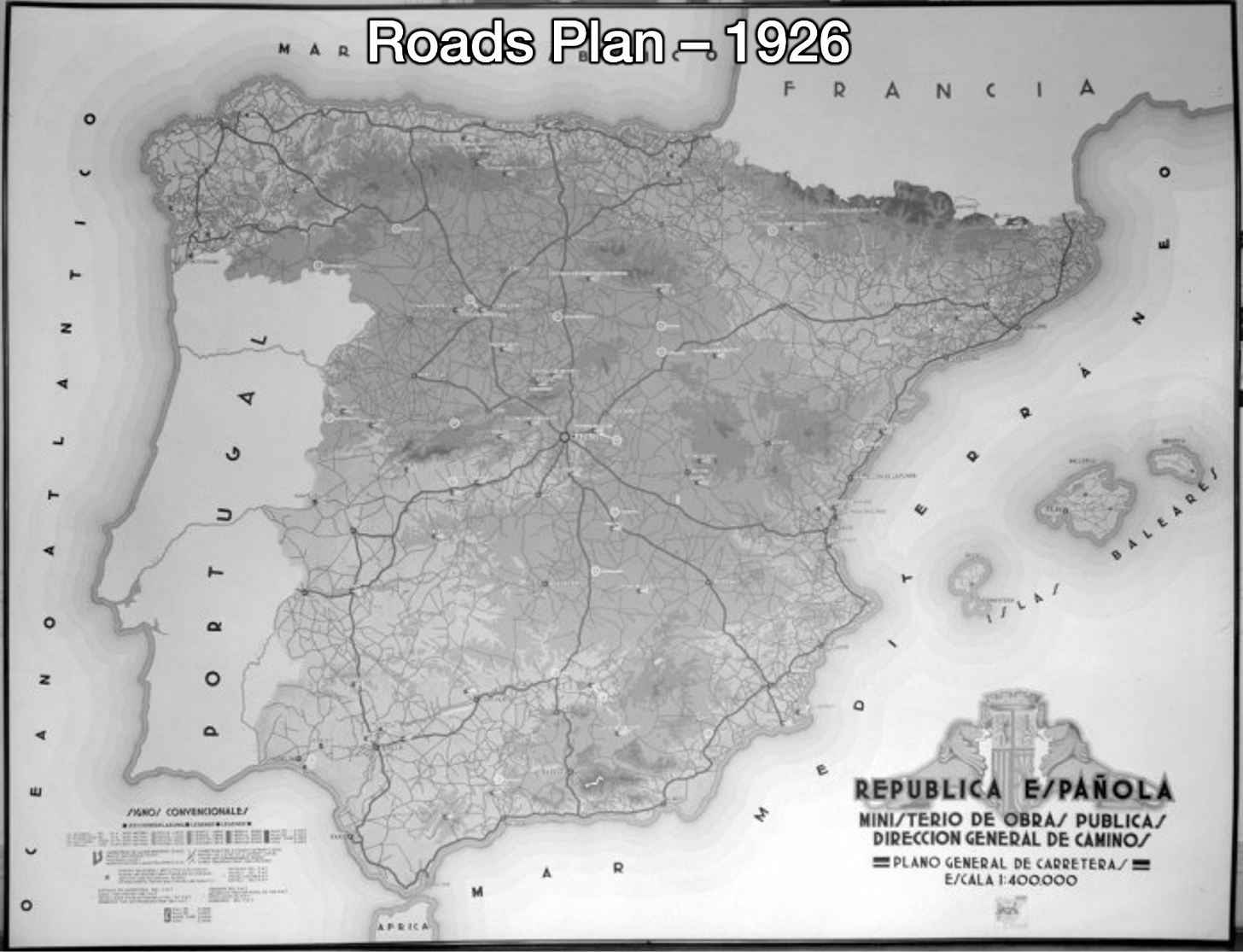
The roads plan in the early 20th Century focused around Madrid as the central node of communications for Spain. The same was true in the late 20th century for the highways plan:
You can see something similar with the railways today, with most of the fast trains (blue) going through Madrid, as well as a lot of the standard railways:
And of course, with the airports:
So much so that Madrid’s airport is the 5th busiest in Europe.
All of this infrastructure has meant more trade, more wealth, more specialization, more investment, etc…
Notice that Barcelona’s population was close to Madrid’s for a very long time. There are many reasons for that, but a key one is that Barcelona is a port city, so it could compete on Mediterranean—and eventually global—multimodal trade in a way that Madrid couldn’t.
But the role of network effects is hard to escape: Bigger cities become bigger, and suck the population from neighboring cities.
All of this is very similar to what we covered with Chicago: It started as the market platform between the Mississippi River and the Great Lakes through riverine trade.
From there, it became a key node of the railways system:
And the highway system:
And eventually developed one of the biggest airports in the world and the biggest commodities market in the world.
Following a similar path—helped by a bit of luck due to Philip II’s tastes—is how Madrid transformed from a small backwater city into the second largest city and metropolitan area in the European Union—only after Paris—and a global capital.
Except for Seville and the Guadalquivir. In fact Seville was the biggest and wealthiest city at the time because of the Guadaliquivir: It was its head of navigation.


Good recap.
The only thing I would add is some context on why it was important for Philip II to find a city without any rival powers. Philip's father, Emperor Charles V, arrive as king of Spain in 1521, without much understanding of local politics (not even speaking Spanish). This resulted in the Revolt of the Comuneros, where an important part of nobility (including people from Toledo) raised against him.
This made crucial for his son to have a clear power strategy without any possible contestant, and changing the capital city to Madrid was perfect (for all the reasons you exposed).
Thanks for this article!
I think this is wonderful and so many of us don't really have a good background in world history and geography. I a world that is so connected this column is a wonderful resource to all.